|
search place name
|
||
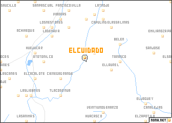
El Cuidado (Zacatecas, Mexico)El Cuidado is a town in the Zacatecas region of Mexico. An overview map of the region around El Cuidado is displayed below.
regional and 3d topo map of El Cuidado, Mexico ::
El Cuidado airports ::
The nearest airport is ZCL - Zacatecas General Leobardo C Ruiz Intl, located 76.5 km north east of El Cuidado.
Other airports nearby include AGU - Aguascalientes Jesus Teran Intl (107.9 km south east), GDL - Guadalajara Don Miguel Hidalgo Y Costilla Intl (201.6 km south), TPQ - Tepic (205.1 km south west), BJX - Del Bajio Guanajuato Intl (225.1 km south east), Nearby towns ::
El Recuerdo (2.5km north east) //
El Laurel (5.5km east) //
Ciénega Grande (6.3km south west) //
Tarasco (6.9km east) //
El Ciudado (8.2km north west) //
Belén (7.8km north east) //
Tlacosanua (9.0km south west) //
Lo de Nava (8.8km north west) //
Capulín de las Salinas (9.0km north east) //
Los Nestores (10.1km north west) //
[all distances 'as the bird flies' and approximate]  Places with similar names to El Cuidado, Mexico ::
// El Ktout (MA)
// Elkatdeh (IR)
// El Codito (CO)
// El Gatito (MX)
// El Ocotito (MX)
// El Caudate (HN)
// El Cotudo (VE)
// El Catete (UY)
// El Koudiat (DZ)
// El Gateado (AR)
Disclaimer :: Information on this page comes without warranty of any kind |
||
|
Where is El Cuidado? Elevation and coordinates ::
Latitude (lat): 22°20'0"N Longitude (lon): 103°7'0"W
Elevation (approx.): 1855m (map arrows pan, magnifying glasses zoom) |
||
|
Visiting El Cuidado? Hotel/Accommodation ::
Book a hotel in El Cuidado Travel Guide ::
Buy a travel guide for Mexico rental cars ::
car rental offers GPS waypoint ::
download a GPX waypoint (PoI) of El Cuidado for your GPS receiver
|
||