|
search place name
|
||
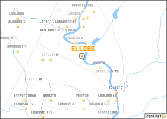
El Lobo (Tamaulipas, Mexico)El Lobo is a town in the Tamaulipas region of Mexico. An overview map of the region around El Lobo is displayed below.
regional and 3d topo map of El Lobo, Mexico ::
El Lobo airports ::
The nearest airport is NLD - Nuevo Laredo Quetzalcoatl Intl, located 20.8 km north of El Lobo.
Other airports nearby include LRD - Laredo Intl (30.9 km north), ALI - Alice Intl (154.7 km east), NQI - Kingsville Nas (169.3 km east), NTR - Monterrey Del Norte Intl (171.7 km south west), Nearby towns ::
Puerto (3.8km south east) //
San Pedro (4.1km north west) //
Latitas (6.2km north west) //
San Silvestre (6.2km south east) //
El Capullo (6.2km south east) //
El Recuerdo (7.4km north) //
San Rubén (6.6km west) //
Ventanillas de Abajo (7.4km north west) //
Santa Rosa (8.1km north west) //
Ventanillas de Arriba (8.9km north west) //
Santa Clara (9.9km south east) //
Soledad (9.9km south east) //
[all distances 'as the bird flies' and approximate] 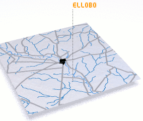 Places with similar names to El Lobo, Mexico ::
Disclaimer :: Information on this page comes without warranty of any kind |
||
|
Where is El Lobo? Elevation and coordinates ::
Latitude (lat): 27°16'0"N Longitude (lon): 99°30'0"W
Elevation (approx.): 114m (map arrows pan, magnifying glasses zoom) |
||
|
Visiting El Lobo? Hotel/Accommodation ::
Book a hotel in El Lobo Travel Guide ::
Buy a travel guide for Mexico rental cars ::
car rental offers GPS waypoint ::
download a GPX waypoint (PoI) of El Lobo for your GPS receiver
|
||