|
search place name
|
||
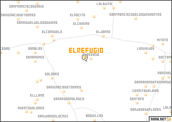
El Refugio (Nuevo León, Mexico)El Refugio is a town in the Nuevo León region of Mexico. An overview map of the region around El Refugio is displayed below.
regional and 3d topo map of El Refugio, Mexico ::
El Refugio airports ::
The nearest airport is CVM - Ciudad Victoria General Pedro Jose Mendez Intl, located 142.2 km east of El Refugio.
Other airports nearby include SLP - San Luis Potosi Ponciano Arriaga Intl (167.4 km south), SLW - Saltillo Plan De Guadalupe Intl (216.6 km north), TSL - Tamuin (240.0 km south east), AGU - Aguascalientes Jesus Teran Intl (296.7 km south west), Nearby towns ::
El Repaso (1.1km north east) //
San Agustín de Valdez (6.5km south) //
El Jarro (6.5km north east) //
El Chiripa (7.3km north) //
San Ignacio de Torres (8.0km south west) //
Dolores (7.7km south west) //
Alvaro Obregón (8.0km north west) //
El Consuelo (8.8km north west) //
[all distances 'as the bird flies' and approximate] 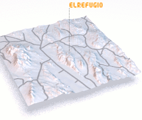 Places with similar names to El Refugio, Mexico ::
// El Refugio (US)
// El Refugio (US)
// El Refugio (SV)
// El Refugio (SV)
// El Refugio (SV)
// El Refugio (GT)
// El Refugio (GT)
// El Refugio (GT)
// El Refugio (GT)
// El Refugio (MX)
Disclaimer :: Information on this page comes without warranty of any kind |
||
|
Where is El Refugio? Elevation and coordinates ::
Latitude (lat): 23°40'0"N Longitude (lon): 100°21'0"W
Elevation (approx.): 1857m (map arrows pan, magnifying glasses zoom) |
||
|
Visiting El Refugio? Hotel/Accommodation ::
Book a hotel in El Refugio Travel Guide ::
Buy a travel guide for Mexico rental cars ::
car rental offers GPS waypoint ::
download a GPX waypoint (PoI) of El Refugio for your GPS receiver
|
||