|
search place name
|
||
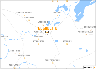
El Saucito (Tamaulipas, Mexico)El Saucito is a town in the Tamaulipas region of Mexico. An overview map of the region around El Saucito is displayed below.
regional and 3d topo map of El Saucito, Mexico ::
El Saucito airports ::
The nearest airport is MAM - Matamoros General Servando Canales Intl, located 121.4 km north of El Saucito.
Other airports nearby include BRO - Brownsville South Padre Island Intl (139.2 km north east), REX - Reynosa General Lucio Blanco Intl (141.9 km north), CVM - Ciudad Victoria General Pedro Jose Mendez Intl (153.5 km south west), MFE - Mcallen Mc Allen Miller Intl (160.3 km north), Nearby towns ::
La Rinconada (2.5km north west) //
Muralla (3.4km west) //
La Florida (4.1km north west) //
La Purísima (3.8km south west) //
La Esperanza (5.0km south west) //
Las Norias (7.7km south east) //
La Parra (8.1km north east) //
Laguna Seca (8.7km north west) //
División del Norte (8.7km north west) //
[all distances 'as the bird flies' and approximate] 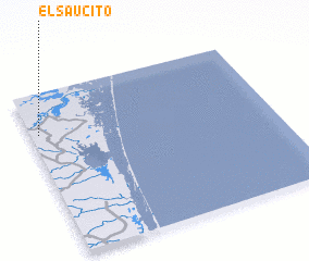 Places with similar names to El Saucito, Mexico ::
// El Saucito (MX)
// El Saucito (MX)
// El Saucito (MX)
// El Saucito (MX)
// El Saucito (MX)
// El Saucito (MX)
// El Saucito (MX)
// El Saucito (MX)
// El Saucito (MX)
// El Saucito (MX)
Disclaimer :: Information on this page comes without warranty of any kind |
||
|
Where is El Saucito? Elevation and coordinates ::
Latitude (lat): 24°45'0"N Longitude (lon): 97°58'0"W
Elevation (approx.): 20m (map arrows pan, magnifying glasses zoom) |
||
|
Visiting El Saucito? Hotel/Accommodation ::
Book a hotel in El Saucito Travel Guide ::
Buy a travel guide for Mexico rental cars ::
car rental offers GPS waypoint ::
download a GPX waypoint (PoI) of El Saucito for your GPS receiver
|
||