|
search place name
|
||
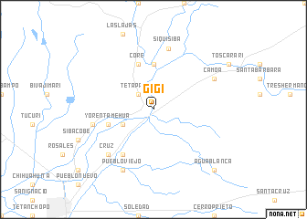
Gigí (Sonora, Mexico)Gigí is a town in the Sonora region of Mexico. An overview map of the region around Gigí is displayed below.
regional and 3d topo map of Gigí, Mexico ::
Gigí airports ::
The nearest airport is CEN - Ciudad Obregon Intl, located 53.2 km north west of Gigí.
Other airports nearby include LMM - Los Mochis Valle Del Fuerte Intl (168.1 km south), GYM - Guaymas General Jose Maria Yanez Intl (178.2 km north west), LTO - Loreto Intl (239.0 km south west), HMO - Hermosillo General Ignacio P Garcia Intl (269.7 km north west), Nearby towns ::
Tetapache (2.5km north west) //
Tesia (3.8km south west) //
Santa Rosa (5.6km north) //
Yorentamehua (5.3km west) //
Core (5.8km north) //
Choaroa (6.5km south west) //
El Taste (6.9km west) //
Siquisiba (7.6km north) //
Cruz (7.4km south west) //
Pueblo Viejo (8.1km south west) //
Camoa (7.6km north east) //
Agua Blanca (9.9km south east) //
[all distances 'as the bird flies' and approximate] 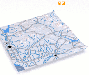 Places with similar names to Gigí, Mexico ::
Disclaimer :: Information on this page comes without warranty of any kind |
||
|
Where is Gigí? Elevation and coordinates ::
Latitude (lat): 27°11'0"N Longitude (lon): 109°21'0"W
Elevation (approx.): 51m (map arrows pan, magnifying glasses zoom) |
||
|
Visiting Gigí? Hotel/Accommodation ::
Book a hotel in Gigí Travel Guide ::
Buy a travel guide for Mexico rental cars ::
car rental offers GPS waypoint ::
download a GPX waypoint (PoI) of Gigí for your GPS receiver
|
||