|
search place name
|
||
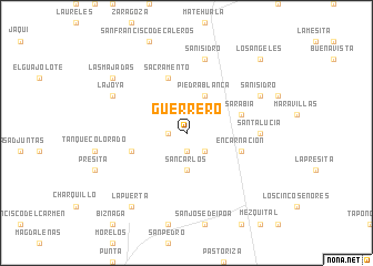
Guerrero (San Luis Potosí, Mexico)Guerrero is a town in the San Luis Potosí region of Mexico. An overview map of the region around Guerrero is displayed below.
regional and 3d topo map of Guerrero, Mexico ::
Guerrero airports ::
The nearest airport is SLP - San Luis Potosi Ponciano Arriaga Intl, located 146.0 km south of Guerrero.
Other airports nearby include CVM - Ciudad Victoria General Pedro Jose Mendez Intl (175.3 km east), SLW - Saltillo Plan De Guadalupe Intl (223.1 km north), TSL - Tamuin (254.0 km south east), AGU - Aguascalientes Jesus Teran Intl (265.6 km south west), Nearby towns ::
Viboritas (1.7km west) //
La Puerta (1.9km south) //
Jalpa (2.5km south east) //
San Carlos (3.7km south) //
Piedra Blanca (4.1km north east) //
Sacramento (5.8km north) //
Sarabia (5.4km east) //
Encarnación (5.4km east) //
Puerto (5.4km west) //
Santa Lucía (6.8km east) //
San Isidro (7.6km north) //
La Joya (7.7km north west) //
San Isidro (7.7km north east) //
Las Majadas (8.8km north west) //
La Puerta (9.0km south west) //
Los Ángeles (10.1km north east) //
[all distances 'as the bird flies' and approximate] 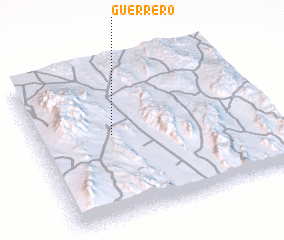 Places with similar names to Guerrero, Mexico ::
Disclaimer :: Information on this page comes without warranty of any kind |
||
|
Where is Guerrero? Elevation and coordinates ::
Latitude (lat): 23°33'0"N Longitude (lon): 100°40'0"W
Elevation (approx.): 1600m (map arrows pan, magnifying glasses zoom) |
||
|
Visiting Guerrero? Hotel/Accommodation ::
Book a hotel in Guerrero Travel Guide ::
Buy a travel guide for Mexico rental cars ::
car rental offers GPS waypoint ::
download a GPX waypoint (PoI) of Guerrero for your GPS receiver
|
||