|
search place name
|
||
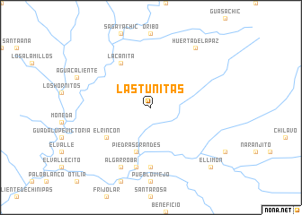
Las Tunitas (Chihuahua, Mexico)Las Tunitas is a town in the Chihuahua region of Mexico. An overview map of the region around Las Tunitas is displayed below.
regional and 3d topo map of Las Tunitas, Mexico ::
Las Tunitas airports ::
The nearest airport is CEN - Ciudad Obregon Intl, located 144.3 km west of Las Tunitas.
Other airports nearby include LMM - Los Mochis Valle Del Fuerte Intl (218.0 km south), Nearby towns ::
Los Naranjitos (5.8km south) //
Piedras Grandes (5.8km south) //
El Rincón (6.2km south west) //
La Cañita (6.5km north west) //
Tepochique (7.4km south) //
Limón (7.6km south) //
Algarroba (8.1km south west) //
Huerta de la Paz (8.9km north east) //
El Limón (9.9km south east) //
[all distances 'as the bird flies' and approximate] 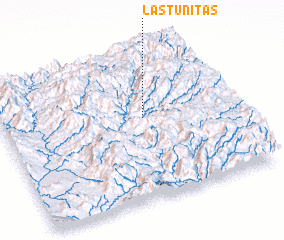 Places with similar names to Las Tunitas, Mexico ::
// Los Duendes (PA)
// Los Duendes (PA)
// Las Tiendas (ES)
// Las Tiendas (ES)
// Los Donatos (ES)
// Las Tiendas (US)
// Las Dañadas (CO)
// Los Dindes (CO)
// Los Duendes (CO)
// Los Duendes (CO)
Disclaimer :: Information on this page comes without warranty of any kind |
||
|
Where is Las Tunitas? Elevation and coordinates ::
Latitude (lat): 27°33'0"N Longitude (lon): 108°23'0"W
Elevation (approx.): 1518m (map arrows pan, magnifying glasses zoom) |
||
|
Visiting Las Tunitas? Hotel/Accommodation ::
Book a hotel in Las Tunitas Travel Guide ::
Buy a travel guide for Mexico rental cars ::
car rental offers GPS waypoint ::
download a GPX waypoint (PoI) of Las Tunitas for your GPS receiver
|
||