|
search place name
|
||
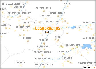
Los Duraznos (México, Mexico)Los Duraznos is a town in the México region of Mexico. An overview map of the region around Los Duraznos is displayed below.
regional and 3d topo map of Los Duraznos, Mexico ::
Los Duraznos airports ::
The nearest airport is TLC - Toluca Licenciado Adolfo Lopez Mateos Intl, located 40.6 km south west of Los Duraznos.
Other airports nearby include MEX - Mexico City Licenciado Benito Juarez Intl (43.1 km south east), PCA - Pachuca Ingeniero Juan Guillermo Villasana (79.0 km north east), CVJ - Cuernavaca General Mariano Matamoros (93.5 km south), PBC - Puebla Hermanos Serdan Intl (122.1 km south east), Nearby towns ::
San Juan de las Tablas (2.7km west) //
El Puerto de Magú (3.0km north east) //
San José el Vidrio (3.3km south east) //
Cahuacán (3.6km south west) //
Cacahuacán (4.2km south) //
El Gavillero (4.3km north east) //
Vidrio (4.2km south east) //
Caja de Agua (4.4km south east) //
San Francisco Magú (5.2km east) //
Loma Alta (5.6km west) //
San Martín Cachíhuapan (5.9km north west) //
San Jerónimo (6.0km south) //
Los Dolores (6.2km north) //
Progreso Industrial (6.5km south east) //
María Magdalena (6.7km south west) //
Lanzarote (7.0km east) //
Loma del Río (7.3km south east) //
Las Cabañas (7.3km north east) //
Cañada de Cisneros (7.5km north east) //
San Antonio (7.6km north west) //
San Miguel Cañadas (7.9km north east) //
Santa Gertrudis (8.1km north east) //
El Ocotal (7.7km west) //
Ejido de Cahuacán (8.2km south) //
El Varal (7.8km west) //
San Miguel Cañadas (8.2km north east) //
Las Cabañas (8.4km north east) //
Loma del Río (9.6km south east) //
Villa del Carbón (9.5km north west) //
[all distances 'as the bird flies' and approximate] 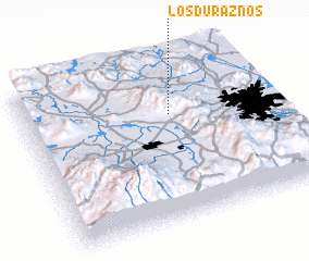 Places with similar names to Los Duraznos, Mexico ::
// Los Duraznos (MX)
// Los Duraznos (MX)
// Los Duraznos (HN)
// Los Duraznos (HN)
// Les Terrassonnes (FR)
Disclaimer :: Information on this page comes without warranty of any kind |
||
|
Where is Los Duraznos? Elevation and coordinates ::
Latitude (lat): 19°40'7"N Longitude (lon): 99°24'6"W
Elevation (approx.): 2581m (map arrows pan, magnifying glasses zoom) |
||
|
Visiting Los Duraznos? Hotel/Accommodation ::
Book a hotel in Los Duraznos Travel Guide ::
Buy a travel guide for Mexico rental cars ::
car rental offers GPS waypoint ::
download a GPX waypoint (PoI) of Los Duraznos for your GPS receiver
|
||