|
search place name
|
||
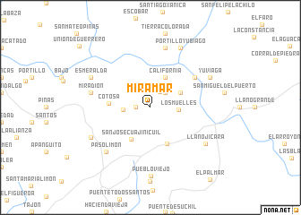
Miramar (Oaxaca, Mexico)Miramar is a town in the Oaxaca region of Mexico. An overview map of the region around Miramar is displayed below.
regional and 3d topo map of Miramar, Mexico ::
Miramar airports ::
The nearest airport is HUX - Bahias Dehuatulco Bahias De Huatulco Intl, located 13.9 km south of Miramar.
Other airports nearby include PXM - Puerto Escondido Intl (89.9 km west), OAX - Oaxaca Xoxocotlan Intl (131.9 km north west), Nearby towns ::
San Pablo (1.8km west) //
Loma Larga (2.3km north east) //
Camila (2.6km north east) //
Cuajinicuil (3.3km west) //
Los Muelles (3.4km east) //
Costa Rica (4.0km north east) //
El Súchil (4.0km north east) //
Alemania (4.1km north east) //
California (4.1km north east) //
San José Cuajinicuil (4.5km south west) //
Arroyo Súchil (4.9km south east) //
Cotosa (5.0km west) //
Piedras Negras (6.5km north east) //
Miradión (7.4km west) //
Fruta del Cajón (7.6km north) //
Paso Limón (7.7km south west) //
Llano Jícara (8.0km south east) //
Portillo Yubiago (8.2km north east) //
Yuviaga (8.0km north east) //
Esmeralda (8.0km north west) //
Benito Juárez (8.0km south west) //
Pueblo Viejo (8.6km south) //
Unión de Guerrero (11.5km north west) //
[all distances 'as the bird flies' and approximate] 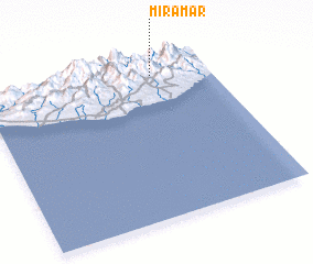 Places with similar names to Miramar, Mexico ::
Disclaimer :: Information on this page comes without warranty of any kind |
||
|
Where is Miramar? Elevation and coordinates ::
Latitude (lat): 15°54'0"N Longitude (lon): 96°15'0"W
Elevation (approx.): 835m (map arrows pan, magnifying glasses zoom) |
||
|
Visiting Miramar? Hotel/Accommodation ::
Book a hotel in Miramar Travel Guide ::
Buy a travel guide for Mexico rental cars ::
car rental offers GPS waypoint ::
download a GPX waypoint (PoI) of Miramar for your GPS receiver
|
||