|
search place name
|
||
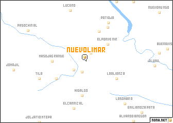
Nuevo Limar (Chiapas, Mexico)Nuevo Limar is a town in the Chiapas region of Mexico. An overview map of the region around Nuevo Limar is displayed below.
regional and 3d topo map of Nuevo Limar, Mexico ::
Nuevo Limar airports ::
The nearest airport is VSA - Villahermosa C P A Carlos Rovirosa Intl, located 77.0 km north west of Nuevo Limar.
Other airports nearby include TGZ - Tuxtla Gutierrez Angel Albino Corzo (117.8 km south west), CME - Ciudad Del Carmen Intl (148.9 km north east), CBV - Coban (303.6 km south east), Nearby towns ::
La Revancha (2.1km north east) //
El Limar (2.5km south) //
El Triunfo (3.2km south west) //
El Porvenir (5.8km north east) //
Shinteajá (7.0km north) //
Masojá Grande (7.1km west) //
Hidalgo (7.5km south) //
Miguel Alemán (7.2km south west) //
La Alianza (7.2km south east) //
Trinidad (8.6km north east) //
Patiojá (9.6km north east) //
[all distances 'as the bird flies' and approximate] 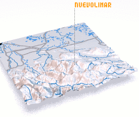 Places with similar names to Nuevo Limar, Mexico ::
// Navalmoro (ES)
Disclaimer :: Information on this page comes without warranty of any kind |
||
|
Where is Nuevo Limar? Elevation and coordinates ::
Latitude (lat): 17°26'0"N Longitude (lon): 92°23'30"W
Elevation (approx.): 89m (map arrows pan, magnifying glasses zoom) |
||
|
Visiting Nuevo Limar? Hotel/Accommodation ::
Book a hotel in Nuevo Limar Travel Guide ::
Buy a travel guide for Mexico rental cars ::
car rental offers GPS waypoint ::
download a GPX waypoint (PoI) of Nuevo Limar for your GPS receiver
|
||