|
search place name
|
||
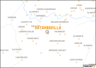
Patambarillo (Michoacán de Ocampo, Mexico)Patambarillo is a town in the Michoacán de Ocampo region of Mexico. An overview map of the region around Patambarillo is displayed below.
regional and 3d topo map of Patambarillo, Mexico ::
Patambarillo airports ::
The nearest airport is ZMM - Zamora, located 44.8 km west of Patambarillo.
Other airports nearby include UPN - Uruapan Licenciado Y Gen Ignacio Lopez Rayon (83.7 km south), MLM - Morelia General Francisco J Mujica Intl (92.6 km east), BJX - Del Bajio Guanajuato Intl (103.0 km north), GDL - Guadalajara Don Miguel Hidalgo Y Costilla Intl (157.7 km west), Nearby towns ::
La Colorada (3.2km north west) //
Tacámbaro (4.4km east) //
Ziquítaro (4.7km north west) //
Ranchos Epeján (5.1km south east) //
San José de Rábago (5.7km north east) //
Penjamillo de Degollado (5.7km south west) //
Curicipo (6.1km east) //
Tirimacuaro (6.2km south west) //
Guándaro (6.7km north west) //
Fresno de la Reforma (7.9km south) //
Santa Fe del Río (7.9km north) //
San Miguel Epeján (8.2km south east) //
Los Arroyuelos (7.8km west) //
Anishuacaro (8.2km north east) //
Ancihuacaro (8.6km north east) //
Corrales de Rábago (8.8km north) //
Potrerillos del Río (8.8km north east) //
La Cuestita (8.7km north west) //
El Carmen (9.2km north west) //
Ziquitaro (9.4km south east) //
Guandarillo (10.2km north east) //
El Palmito (10.8km north west) //
[all distances 'as the bird flies' and approximate] 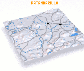 Places with similar names to Patambarillo, Mexico :: Disclaimer :: Information on this page comes without warranty of any kind |
||
|
Where is Patambarillo? Elevation and coordinates ::
Latitude (lat): 20°8'0"N Longitude (lon): 101°51'30"W
Elevation (approx.): 1791m (map arrows pan, magnifying glasses zoom) |
||
|
Visiting Patambarillo? Hotel/Accommodation ::
Book a hotel in Patambarillo Travel Guide ::
Buy a travel guide for Mexico rental cars ::
car rental offers GPS waypoint ::
download a GPX waypoint (PoI) of Patambarillo for your GPS receiver
|
||