|
search place name
|
||
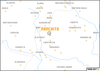
Ranchito (Oaxaca, Mexico)Ranchito is a town in the Oaxaca region of Mexico. An overview map of the region around Ranchito is displayed below.
regional and 3d topo map of Ranchito, Mexico ::
Ranchito airports ::
The nearest airport is PXM - Puerto Escondido Intl, located 58.2 km south of Ranchito.
Other airports nearby include OAX - Oaxaca Xoxocotlan Intl (74.0 km north east), HUX - Bahias Dehuatulco Bahias De Huatulco Intl (107.6 km south east), Nearby towns ::
Yerba Santa (1.9km south) //
Santa Ana (1.9km north) //
La Estancia (3.8km south) //
Ojo de Agua (4.1km north west) //
Platanar (4.0km south west) //
Sabinos (4.0km north west) //
Moral (5.6km north) //
Honduras (5.8km south) //
Lazo (7.4km north) //
San Agustín (7.3km east) //
Cacalote (7.6km south) //
Potrerillo (7.6km south east) //
San Cristóbal Honduras (8.3km south) //
Ciruelo (8.2km south west) //
San Pedro Juchatengo (9.0km south west) //
Chichicaxtle (9.0km south west) //
Estacas (9.1km north west) //
[all distances 'as the bird flies' and approximate] 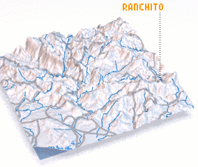 Places with similar names to Ranchito, Mexico ::
Disclaimer :: Information on this page comes without warranty of any kind |
||
|
Where is Ranchito? Elevation and coordinates ::
Latitude (lat): 16°24'0"N Longitude (lon): 97°2'0"W
Elevation (approx.): 1181m (map arrows pan, magnifying glasses zoom) |
||
|
Visiting Ranchito? Hotel/Accommodation ::
Book a hotel in Ranchito Travel Guide ::
Buy a travel guide for Mexico rental cars ::
car rental offers GPS waypoint ::
download a GPX waypoint (PoI) of Ranchito for your GPS receiver
|
||