|
search place name
|
||
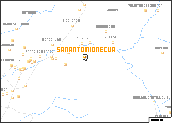
San Antonio Necua (Baja California, Mexico)San Antonio Necua is a town in the Baja California region of Mexico. An overview map of the region around San Antonio Necua is displayed below.
regional and 3d topo map of San Antonio Necua, Mexico ::
San Antonio Necua airports ::
The nearest airport is ESE - Ensenada, located 33.9 km south of San Antonio Necua.
Other airports nearby include TIJ - Tijuana General Abelardo L Rodriguez Intl (68.4 km north west), NZY - San Diego North Island Nas (97.0 km north west), SAN - San Diego Intl (98.1 km north west), NKX - Miramar Mcas (106.9 km north west), Nearby towns ::
Cañada de los Encinos (2.8km north west) //
Los Milagros (4.1km north) //
Agua Caliente (3.8km north east) //
Cañada Ancha (3.7km north west) //
Las Bellotas (4.2km north) //
Sierra Blanca (3.8km west) //
Encinal (4.3km north west) //
El Milagro (5.6km west) //
Valle Seco (6.5km north east) //
Miramontes (6.2km west) //
López (6.5km west) //
San Marcos (7.6km north east) //
Sordomudo (7.1km north west) //
La Aurora (8.1km north) //
[all distances 'as the bird flies' and approximate]  Places with similar names to San Antonio Necua, Mexico :: Disclaimer :: Information on this page comes without warranty of any kind |
||
|
Where is San Antonio Necua? Elevation and coordinates ::
Latitude (lat): 32°5'0"N Longitude (lon): 116°29'0"W
Elevation (approx.): 620m (map arrows pan, magnifying glasses zoom) |
||
|
Visiting San Antonio Necua? Hotel/Accommodation ::
Book a hotel in San Antonio Necua Travel Guide ::
Buy a travel guide for Mexico rental cars ::
car rental offers GPS waypoint ::
download a GPX waypoint (PoI) of San Antonio Necua for your GPS receiver
|
||