|
search place name
|
||
San Sebastián (Nayarit, Mexico)San Sebastián is a town in the Nayarit region of Mexico. An overview map of the region around San Sebastián is displayed below.
regional and 3d topo map of San Sebastián, Mexico ::

San Sebastián airports ::
The nearest airport is TPQ - Tepic, located 79.6 km south east of San Sebastián.
Other airports nearby include PVR - Puerto Vallarta Licenciado Gustavo Diaz Ordaz Intl (128.1 km south), MZT - Mazatlan General Rafael Buelna Intl (169.3 km north west), Nearby towns ::
Chaguita (5.1km north east) //
La Concha (5.6km south) //
Toro Mocho (6.5km south east) //
Los Algodones (7.6km south east) //
Zapotlán (10.1km north east) //
[all distances 'as the bird flies' and approximate] 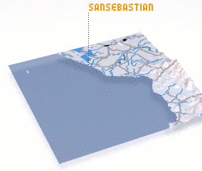 Places with similar names to San Sebastián, Mexico ::
// San Sebastian (PA)
// San Sebastiano (IT)
// San Sebastiano (IT)
// San Sebastiano (IT)
// San Sebastián (CU)
// San Sebastián (CU)
// San Sebastián (CU)
// San Sebastián (ES)
// San Sebastián (ES)
// San Sebastian (CO)
Disclaimer :: Information on this page comes without warranty of any kind |
||
|
Where is San Sebastián? Elevation and coordinates ::
Latitude (lat): 21°49'0"N Longitude (lon): 105°29'0"W
Elevation (approx.): 4m (map arrows pan, magnifying glasses zoom) |
||
|
Visiting San Sebastián? Hotel/Accommodation ::
Book a hotel in San Sebastián Travel Guide ::
Buy a travel guide for Mexico rental cars ::
car rental offers GPS waypoint ::
download a GPX waypoint (PoI) of San Sebastián for your GPS receiver
|
||