|
search place name
|
||
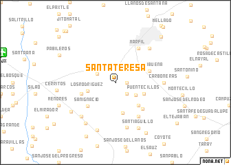
Santa Teresa (Guanajuato, Mexico)Santa Teresa is a town in the Guanajuato region of Mexico. An overview map of the region around Santa Teresa is displayed below.
regional and 3d topo map of Santa Teresa, Mexico ::
Santa Teresa airports ::
The nearest airport is BJX - Del Bajio Guanajuato Intl, located 17.7 km west of Santa Teresa.
Other airports nearby include QRO - Queretaro Intercontinental (123.4 km east), MLM - Morelia General Francisco J Mujica Intl (125.5 km south), AGU - Aguascalientes Jesus Teran Intl (133.4 km north west), ZMM - Zamora (141.6 km south west), Nearby towns ::
Pirul (1.7km east) //
Santa Catarina de Cuevas (2.5km south east) //
El Chapulin de la Cuesta (3.1km north west) //
El Maluco (3.8km south east) //
Los Rodríguez (4.4km west) //
Puentecillos (4.7km south east) //
Cañada de Bustos (5.1km south) //
Cuevas (5.1km south east) //
Troje de Olivares (5.5km west) //
Yerbabuena (5.5km east) //
San Ignacio (5.7km south west) //
Cajones (5.9km south east) //
Marfil (6.5km north east) //
Molineros (6.5km south east) //
El Capulín (7.5km south) //
Calaverna (7.6km south west) //
Herrera (7.6km north east) //
Carboneras (7.4km east) //
El Espejo (8.0km south west) //
San Andrés de la Baraña (8.2km south) //
Santiaguillo (8.2km south east) //
Refugio de Ocampo (8.3km south west) //
El Zangarro (9.4km south east) //
El Medio Sitio (9.8km south west) //
Guanajuato (10.1km north east) //
El Paraíso (11.2km north west) //
El Coyote (11.4km north west) //
[all distances 'as the bird flies' and approximate]  Places with similar names to Santa Teresa, Mexico ::
// Santa Teresa (BR)
// Santa Teresa (BR)
// Santa Teresa (BR)
// Santa Teresa (BR)
// Santa Teresa (BR)
// Santa Teresa (BR)
// Santa Teresa (BR)
// Santa Teresa (BR)
// Santa Teresa (BR)
// Santa Teresa (BR)
Disclaimer :: Information on this page comes without warranty of any kind |
||
|
Where is Santa Teresa? Elevation and coordinates ::
Latitude (lat): 20°57'0"N Longitude (lon): 101°19'0"W
Elevation (approx.): 1932m (map arrows pan, magnifying glasses zoom) |
||
|
Visiting Santa Teresa? Hotel/Accommodation ::
Book a hotel in Santa Teresa Travel Guide ::
Buy a travel guide for Mexico rental cars ::
car rental offers GPS waypoint ::
download a GPX waypoint (PoI) of Santa Teresa for your GPS receiver
|
||