|
search place name
|
||
Tacochique (Chihuahua, Mexico)Tacochique is a town in the Chihuahua region of Mexico. An overview map of the region around Tacochique is displayed below.
regional and 3d topo map of Tacochique, Mexico ::

Tacochique airports ::
The nearest airport is CEN - Ciudad Obregon Intl, located 141.5 km south west of Tacochique.
Nearby towns ::
Aliso (1.9km south) //
Naranjo (2.5km north east) //
Bacugachic (3.7km south) //
El Ranchito (3.3km west) //
Tacochiquic (4.1km north west) //
La Junta (4.9km north east) //
Teroyvo (4.9km north west) //
Sipachic (5.3km east) //
Tepehuiachiac (6.2km south east) //
Noriega (7.4km south) //
Tojogorachic (6.5km west) //
Guicharaibo (6.8km west) //
La Cañita (7.4km south east) //
Pilas (8.1km south east) //
Bacabuico (8.1km south west) //
San Juan (7.5km south west) //
Río de Ocampo (7.5km north west) //
Calabazas (8.9km south east) //
Salajota (8.9km north east) //
Palo Dulce (8.6km south west) //
[all distances 'as the bird flies' and approximate] 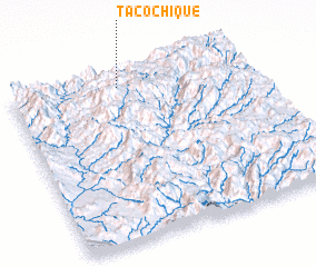 Places with similar names to Tacochique, Mexico ::
// Takoushka (RU)
// Tokoushka (RU)
// Tekeshykhy (AZ)
// Takshak (US)
// Tok-Sheykh (UA)
// Tacachico (SV)
// Tequeáchic (MX)
// Tequichic (MX)
// Dāk Chauki (PK)
// Dāk Chauki (PK)
Disclaimer :: Information on this page comes without warranty of any kind |
||
|
Where is Tacochique? Elevation and coordinates ::
Latitude (lat): 27°56'0"N Longitude (lon): 108°32'0"W
Elevation (approx.): 1186m (map arrows pan, magnifying glasses zoom) |
||
|
Visiting Tacochique? Hotel/Accommodation ::
Book a hotel in Tacochique Travel Guide ::
Buy a travel guide for Mexico rental cars ::
car rental offers GPS waypoint ::
download a GPX waypoint (PoI) of Tacochique for your GPS receiver
|
||