|
search place name
|
||
Tenexac (Tlaxcala, Mexico)Tenexac is a town in the Tlaxcala region of Mexico. An overview map of the region around Tenexac is displayed below.
regional and 3d topo map of Tenexac, Mexico ::

Tenexac airports ::
The nearest airport is TXA - Tlaxcala, located 20.8 km west of Tenexac.
Other airports nearby include PBC - Puebla Hermanos Serdan Intl (55.0 km south west), PCA - Pachuca Ingeniero Juan Guillermo Villasana (106.1 km north west), MEX - Mexico City Licenciado Benito Juarez Intl (114.6 km west), TCN - Tehuacan (124.8 km south east), Nearby towns ::
El Ocote (2.9km west) //
Toluca de Guadalupe (3.3km south east) //
Laguna (3.5km north west) //
Teometitla (4.5km south) //
Lázaro Cárdenas (5.4km north) //
La Noria (5.6km south east) //
Tepeyehualco (6.1km north west) //
Coaxamalucan (5.9km west) //
Santa Fe La Troje (6.3km north west) //
El Carpintero (6.4km east) //
La Mancera (7.2km north east) //
Terrenate (6.9km east) //
Ojo de Agua (7.2km north west) //
Mazorongo (7.3km north east) //
Nicolas Bravo (7.7km south) //
José María Morelos y Pavón (7.3km west) //
Atotonilco (7.7km north east) //
Tlalmotoca (7.6km north east) //
Piedras Negras (7.5km west) //
Capula (7.7km north west) //
Velasco (8.0km south west) //
Loma de Vacas (8.1km north east) //
Tepeyahualco (8.1km south east) //
Baquedano de Galeana (8.3km south) //
Tepexahualco (8.3km north) //
Los Encinos (8.3km north east) //
San Diego Baguedano (8.6km south) //
El Rincón (8.2km east) //
San José Piedras Negras (8.4km south west) //
[all distances 'as the bird flies' and approximate] 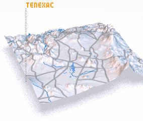 Places with similar names to Tenexac, Mexico ::
// Tunguska (RU)
// Tunguska (RU)
// Tunguska (RU)
// Tunguska (RU)
// Tangasogo (BF)
// Tangassoko (BF)
// Tangazougou (BF)
// Tangséga (BF)
// Tangséga (BF)
// Tangséga (BF)
Disclaimer :: Information on this page comes without warranty of any kind |
||
|
Where is Tenexac? Elevation and coordinates ::
Latitude (lat): 19°29'25"N Longitude (lon): 97°58'55"W
Elevation (approx.): 2550m (map arrows pan, magnifying glasses zoom) |
||
|
Visiting Tenexac? Hotel/Accommodation ::
Book a hotel in Tenexac Travel Guide ::
Buy a travel guide for Mexico rental cars ::
car rental offers GPS waypoint ::
download a GPX waypoint (PoI) of Tenexac for your GPS receiver
|
||