|
search place name
|
||
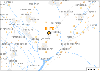
Umyr (Surxondaryo, Uzbekistan)Umyr is a town in the Surxondaryo region of Uzbekistan. An overview map of the region around Umyr is displayed below.
regional and 3d topo map of Umyr, Uzbekistan ::
Umyr airports ::
The nearest airport is DYU - Dushanbe, located 71.0 km east of Umyr.
Other airports nearby include SKD - Samarkand (169.9 km north west), MZR - Mazar-i-sharif Mazar I Sharif (202.0 km south), UND - Kunduz Konduz (208.2 km south), Nearby towns ::
Kudukli (2.2km east) //
Qorashiq (2.7km south west) //
Karamany (3.1km north) //
Khatub (3.2km south east) //
Galyabita (4.1km north east) //
Uzun (4.6km south west) //
Boyragesh (5.1km north) //
Choldzhiyan (5.1km north) //
Telʼpak-Chinar (4.1km west) //
Dzhar-Kishlak (4.8km south west) //
Guraso (4.8km south west) //
Ashor-Dzhilyan (6.3km south) //
Samanchi (6.4km north west) //
Dzhan-Cheke (6.9km south east) //
Novosay (6.2km east) //
Chaqar (6.4km east) //
Sariosiyo (6.4km west) //
Joncheka (7.7km south east) //
Besh-Kapa Pervaya (7.4km south east) //
Chinar (8.7km south) //
Shargʼun (8.6km north west) //
Kichik-Sŭfiyon (9.3km north east) //
Bay-Kishlak (10.3km north west) //
Fazylʼ-Kushty (10.9km north west) //
[all distances 'as the bird flies' and approximate]  Places with similar names to Umyr, Uzbekistan ::
Disclaimer :: Information on this page comes without warranty of any kind |
||
|
Where is Umyr? Elevation and coordinates ::
Latitude (lat): 38°24'19"N Longitude (lon): 68°1'49"E
Elevation (approx.): 576m (map arrows pan, magnifying glasses zoom) |
||
|
Visiting Umyr? Hotel/Accommodation ::
Book a hotel in Umyr Travel Guide ::
Buy a travel guide for Uzbekistan rental cars ::
car rental offers GPS waypoint ::
download a GPX waypoint (PoI) of Umyr for your GPS receiver
|
||