|
search place name
|
||
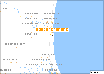
Kampong Badong (Pahang, Malaysia)Kampong Badong is a town in the Pahang region of Malaysia. An overview map of the region around Kampong Badong is displayed below.
regional and 3d topo map of Kampong Badong, Malaysia ::
Kampong Badong airports ::
The nearest airport is KUA - Kuantan, located 91.1 km north of Kampong Badong.
Other airports nearby include JHB - Johor Bahru Sultan Ismail (150.7 km south), MKZ - Malacca (153.7 km south west), KTE - Kerteh (171.8 km north), XSP - Singapore Seletar (179.8 km south), Nearby towns ::
Merchong (1.9km north) //
Pengkalan Balai (3.7km north) //
Kampong Po'ot (4.1km north west) //
Kampong Singir (4.1km north west) //
Kampong Kajang (5.6km north) //
Kampong Tepong (5.9km north) //
Kampong Koat (7.4km west) //
Kampong Palas (7.4km north) //
Kampong Gading (7.6km south) //
Kampong Alor Batu (7.6km west) //
Kampung Gading (8.3km south west) //
Kampong Setelor (8.3km north west) //
Kampong Pauh Bugis (9.3km north west) //
Kampong Jong (9.3km north west) //
Kampong Jabek (10.5km north west) //
Kampong Padang (10.5km north west) //
[all distances 'as the bird flies' and approximate]  Places with similar names to Kampong Badong, Malaysia ::
// Kampong Batungo (TH)
// Kampong Betong (TH)
// Kampong Botong (TH)
// Kampong Batong (BN)
// Kampong Badang (MY)
// Kampong Badang (MY)
// Kampong Badong (MY)
// Kampong Badong (MY)
// Kampong Badong (MY)
// Kampong Batang (MY)
Disclaimer :: Information on this page comes without warranty of any kind |
||
|
Where is Kampong Badong? Elevation and coordinates ::
Latitude (lat): 2°59'0"N Longitude (lon): 103°26'0"E
(map arrows pan, magnifying glasses zoom) |
||
|
Visiting Kampong Badong? Hotel/Accommodation ::
Book a hotel in Kampong Badong Travel Guide ::
Buy a travel guide for Malaysia rental cars ::
car rental offers GPS waypoint ::
download a GPX waypoint (PoI) of Kampong Badong for your GPS receiver
|
||