|
search place name
|
||
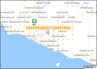
Kampong Bukit Sama Tahu (Melaka, Malaysia)Kampong Bukit Sama Tahu is a town in the Melaka region of Malaysia. An overview map of the region around Kampong Bukit Sama Tahu is displayed below.
regional and 3d topo map of Kampong Bukit Sama Tahu, Malaysia ::
nearby GPS traces from timatio ::
Kampong Bukit Sama Tahu airports ::
The nearest airport is MKZ - Malacca, located 7.5 km north west of Kampong Bukit Sama Tahu.
Other airports nearby include KUL - Kuala Lumpur Intl (87.9 km north west), DUM - Dumai Pinang Kampai (117.5 km south west), JHB - Johor Bahru Sultan Ismail (165.1 km south east), XSP - Singapore Seletar (195.6 km south east), Nearby towns ::
Kampong Bukit Katil (0.0km north) //
Kampong Balik Hutan (1.9km north) //
Kampong Balik Bukit (1.9km south) //
Kampong Bukit Ranting (1.9km south) //
Kampong Bukit Baru (1.9km south) //
Kampong Tengah (1.9km south) //
Kampong Maksamah (1.9km south) //
Kampong Padang Jambu (1.9km west) //
Kampong Pengkalan Minyak (1.9km east) //
Kampong Bukit Baru (1.9km west) //
Kampong Bukit Beruang (2.6km north west) //
Kampong Telok (2.6km north west) //
Bukit Paya Ikan (2.6km north west) //
Kampong Pengkalan Badak (2.6km north east) //
Kampong Padang Kubu (2.6km south west) //
Kampong Permatang (2.6km south east) //
Air Molek (2.6km south east) //
Kampong Ladang (2.6km south west) //
Kampong Parit Keliling (2.6km south east) //
Bukit Baru (2.6km south west) //
Kampong Peringgit (3.7km west) //
Kampong Bukit Baru Dalam (3.7km west) //
Kampong Ayer Molek (3.7km east) //
Kampong Kandang (3.7km south) //
Kampong Alai (3.7km south) //
Kampong Permatang Pasir (3.7km south) //
Kampong Ujong (3.7km south) //
Kampong Pengkalan Ranggam (3.7km south) //
Kampong Pengkalan Batu (4.1km north west) //
[all distances 'as the bird flies' and approximate]  Places with similar names to Kampong Bukit Sama Tahu, Malaysia :: Disclaimer :: Information on this page comes without warranty of any kind |
||
|
Where is Kampong Bukit Sama Tahu? Elevation and coordinates ::
Latitude (lat): 2°13'0"N Longitude (lon): 102°18'0"E
Elevation (approx.): 8m (map arrows pan, magnifying glasses zoom) |
||
|
Visiting Kampong Bukit Sama Tahu? Hotel/Accommodation ::
Book a hotel in Kampong Bukit Sama Tahu Travel Guide ::
Buy a travel guide for Malaysia rental cars ::
car rental offers GPS waypoint ::
download a GPX waypoint (PoI) of Kampong Bukit Sama Tahu for your GPS receiver
|
||