|
search place name
|
||
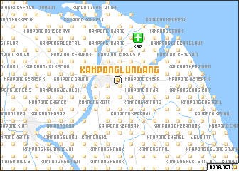
Kampong Lundang (Kelantan, Malaysia)Kampong Lundang is a town in the Kelantan region of Malaysia. An overview map of the region around Kampong Lundang is displayed below.
regional and 3d topo map of Kampong Lundang, Malaysia ::
Kampong Lundang airports ::
The nearest airport is KBR - Kota Bahru Sultan Ismail Petra, located 7.9 km north of Kampong Lundang.
Other airports nearby include NAW - Narathiwat (74.2 km north west), TGG - Kuala Terengganu Sultan Mahmud (122.0 km south east), PAN - Pattani (144.6 km north west), AOR - Alor Setar Sultan Abdul Halim (207.0 km west), Nearby towns ::
Kampong Pasir Ha (0.0km north) //
Kampong Chabang Pasir (1.8km east) //
Kampong Telok Baharu (1.8km east) //
Kampong Padang (1.8km east) //
Kampong Jaya (1.9km south) //
Kampong Bayam (1.9km north) //
Kampong Tiong (1.9km north) //
Kampong Telok Baharu (1.9km north) //
Kampong Jelatang (1.9km south) //
Kampong Kebun Tok Salim (1.9km north) //
Kampong Haji Musa (1.8km west) //
Kampong Bunut Payong (1.8km west) //
Kubang Kerian (2.6km south east) //
Kampong Belukar (2.6km north east) //
Kampong Chicha (2.6km south east) //
Kampong Cherang (2.6km north east) //
Kampong Baung Bayam (2.6km north east) //
Kampong Kenali (2.6km south east) //
Kampong Keranji (2.6km south west) //
Kampong Langgar (2.6km north west) //
Kampong Padang Enggang (2.6km south west) //
Kampong Rumpit (2.6km south west) //
Kampong Beris Harap (3.7km east) //
Kampong Sarah (3.7km east) //
Kampong Wakaf Tanjong (3.7km east) //
Kampong Chepa (3.7km east) //
Kampong Seribang (3.7km south) //
Kampong Setol (3.7km north) //
Kampong Tanjong Mas (3.7km north) //
[all distances 'as the bird flies' and approximate] 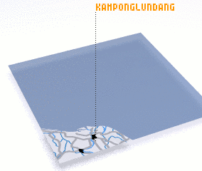 Places with similar names to Kampong Lundang, Malaysia ::
// Kampong Lantuang (MY)
// Kampong Lending (MY)
// Kampong Lintang (MY)
// Kampong Linting (MY)
// Kampong Londang (MY)
// Kampong Lundang (MY)
// Kampung Lentung (MY)
// Kampung Lintang (MY)
// Kampung Lintang (MY)
// Kampung Lintang (MY)
Disclaimer :: Information on this page comes without warranty of any kind |
||
|
Where is Kampong Lundang? Elevation and coordinates ::
Latitude (lat): 6°6'0"N Longitude (lon): 102°16'0"E
Elevation (approx.): 8m (map arrows pan, magnifying glasses zoom) |
||
|
Visiting Kampong Lundang? Hotel/Accommodation ::
Book a hotel in Kampong Lundang Travel Guide ::
Buy a travel guide for Malaysia rental cars ::
car rental offers GPS waypoint ::
download a GPX waypoint (PoI) of Kampong Lundang for your GPS receiver
|
||