|
search place name
|
||
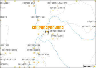
Kampong Panjang (Johor, Malaysia)Kampong Panjang is a town in the Johor region of Malaysia. An overview map of the region around Kampong Panjang is displayed below.
regional and 3d topo map of Kampong Panjang, Malaysia ::
Kampong Panjang airports ::
The nearest airport is MKZ - Malacca, located 67.3 km west of Kampong Panjang.
Other airports nearby include JHB - Johor Bahru Sultan Ismail (120.2 km south east), KUL - Kuala Lumpur Intl (134.1 km west), XSP - Singapore Seletar (153.2 km south east), QPG - Paya Lebar (160.8 km south east), Nearby towns ::
Kampong Tui (0.0km north) //
Kampung Bukit Kepung (1.9km west) //
Kampong Bukit Benador (1.9km north) //
Kampong Bukit Bendar (1.9km east) //
Kampong Raja (2.6km south east) //
Kampong Durian Chondong (3.7km west) //
Kampong Selang (3.7km east) //
Kampong Bukit Bandong (4.1km north west) //
Kampong Tengah (4.1km north west) //
Kampong Laku (4.1km south east) //
Kampong Tekam (6.7km north west) //
Kampong Jawa (7.9km south west) //
Lenga (8.3km south west) //
Kampong Bugis (9.3km south west) //
Kampong Kurnia Sakti (9.3km south west) //
[all distances 'as the bird flies' and approximate]  Places with similar names to Kampong Panjang, Malaysia ::
// Kampong Panjang (MY)
// Kampong Panjang (MY)
// Kampong Panjang (MY)
// Kampong Punjong (MY)
// Kampung Panjang (MY)
// Kampong Panjang (BN)
Disclaimer :: Information on this page comes without warranty of any kind |
||
|
Where is Kampong Panjang? Elevation and coordinates ::
Latitude (lat): 2°21'0"N Longitude (lon): 102°51'0"E
Elevation (approx.): 17m (map arrows pan, magnifying glasses zoom) |
||
|
Visiting Kampong Panjang? Hotel/Accommodation ::
Book a hotel in Kampong Panjang Travel Guide ::
Buy a travel guide for Malaysia rental cars ::
car rental offers GPS waypoint ::
download a GPX waypoint (PoI) of Kampong Panjang for your GPS receiver
|
||