|
search place name
|
||
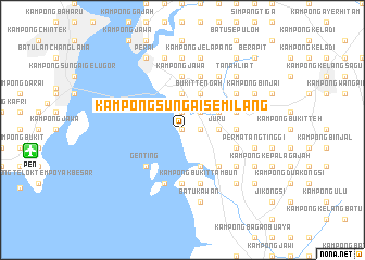
Kampong Sungai Semilang (Pulau Pinang, Malaysia)Kampong Sungai Semilang is a town in the Pulau Pinang region of Malaysia. An overview map of the region around Kampong Sungai Semilang is displayed below.
regional and 3d topo map of Kampong Sungai Semilang, Malaysia ::
Kampong Sungai Semilang airports ::
The nearest airport is PEN - Penang Intl, located 15.6 km west of Kampong Sungai Semilang.
Other airports nearby include AOR - Alor Setar Sultan Abdul Halim (96.6 km north), IPH - Ipoh Sultan Azlan Shah (111.7 km south east), LGK - Pulau Langkawi Intl (135.5 km north west), HDY - Songkhla Hat Yai Intl (178.8 km north), Nearby towns ::
Kampong Bukit Kechil Ujong (0.0km north) //
Kampong Bukit Kechil (0.0km north) //
Kampong Bagan Nyior (1.9km north) //
Kampong Sekolah Juru (1.8km east) //
Kampong To' Kangar (2.6km north east) //
Kampong Kuala Juru (3.7km north) //
Kampong Junjong Mati (3.7km east) //
Juru (3.7km east) //
Kebun Sireh (4.1km north east) //
Bukit Tengah (4.1km north east) //
Kampong Bukit Tengah (4.1km north east) //
Titi Panjang (4.1km north east) //
Kampong Wan Chik (4.1km south east) //
Tanjong Ketupat (5.2km south east) //
Bukit Tambun (5.2km south east) //
Genting (5.2km south west) //
Pengkalan Batu Kawan (5.6km south) //
Kampong To' Panjang (5.6km north) //
Kampong To' Ganti (5.6km north) //
Jalan Baharu (5.6km north) //
Kampong Batu Kawan (5.6km south) //
Kampong Jawa (5.6km north) //
To' Suboh (5.5km east) //
Kampong Bukit Tambun (5.9km south) //
Permatang Kebun Sireh (5.9km north) //
Simpang Empat (5.9km north) //
Kampong Siam (5.9km north) //
Kampong Permatang Batu (5.9km north) //
Kampong Bukit Minyak (5.8km east) //
[all distances 'as the bird flies' and approximate] 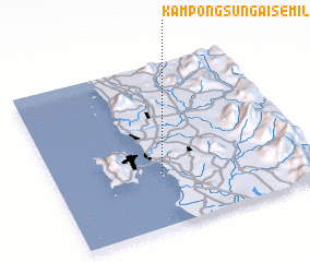 Places with similar names to Kampong Sungai Semilang, Malaysia ::
// Kampong Sungai Sembilang (MY)
// Kampung Sungai Semaliang (MY)
Disclaimer :: Information on this page comes without warranty of any kind |
||
|
Where is Kampong Sungai Semilang? Elevation and coordinates ::
Latitude (lat): 5°19'0"N Longitude (lon): 100°25'0"E
Elevation (approx.): 6m (map arrows pan, magnifying glasses zoom) |
||
|
Visiting Kampong Sungai Semilang? Hotel/Accommodation ::
Book a hotel in Kampong Sungai Semilang Travel Guide ::
Buy a travel guide for Malaysia rental cars ::
car rental offers GPS waypoint ::
download a GPX waypoint (PoI) of Kampong Sungai Semilang for your GPS receiver
|
||