|
search place name
|
||
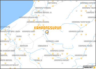
Kampong Surun (Sabah, Malaysia)Kampong Surun is a town in the Sabah region of Malaysia. An overview map of the region around Kampong Surun is displayed below.
regional and 3d topo map of Kampong Surun, Malaysia ::
Kampong Surun airports ::
The nearest airport is BKI - Kota Kinabalu Intl, located 75.3 km south west of Kampong Surun.
Other airports nearby include LBU - Labuan (188.4 km south west), BWN - Brunei Intl (241.2 km south west), LMN - Limbang (245.1 km south west), LDU - Lahad Datu (248.0 km south east), Nearby towns ::
Kampong Rosok (1.9km north) //
Kampong Dulat Dulat (1.8km west) //
Kampong Ginapes (2.6km north west) //
Kampong Ligris (2.6km north west) //
Kampong Kinasapan (2.6km north west) //
Kampong Kaliburan (4.1km north west) //
Kampong Bugaran (4.1km north west) //
Kampong Luba (4.1km south east) //
Kampong Kawang Kawang (5.2km north west) //
Kampong Bangkahak (5.5km west) //
Kampong Losok (5.8km west) //
Kampong Lugo Lugo (5.9km north) //
Kampong Luba (5.9km south) //
Kabidahan (5.9km south) //
Kampong Guan (7.4km west) //
Kampong Tapinatan (7.6km north) //
Kampong Pandasan (7.6km north) //
Kampong Bongaliu (7.6km north) //
Kampong Bahaden (7.6km south) //
Kampong Pindaken (7.6km south) //
Penampang (7.8km north west) //
Kampong Ranau (8.3km north west) //
Kampong Gunok (8.3km south east) //
Kampong Lasau (9.2km south east) //
Kampong Christian (9.2km south east) //
Kampong Kagurahan (9.2km north west) //
Kampong Pompud (10.5km south east) //
Kampong Podi (10.5km south east) //
[all distances 'as the bird flies' and approximate]  Places with similar names to Kampong Surun, Malaysia ::
Disclaimer :: Information on this page comes without warranty of any kind |
||
|
Where is Kampong Surun? Elevation and coordinates ::
Latitude (lat): 6°24'0"N Longitude (lon): 116°33'0"E
Elevation (approx.): 54m (map arrows pan, magnifying glasses zoom) |
||
|
Visiting Kampong Surun? Hotel/Accommodation ::
Book a hotel in Kampong Surun Travel Guide ::
Buy a travel guide for Malaysia rental cars ::
car rental offers GPS waypoint ::
download a GPX waypoint (PoI) of Kampong Surun for your GPS receiver
|
||