|
search place name
|
||
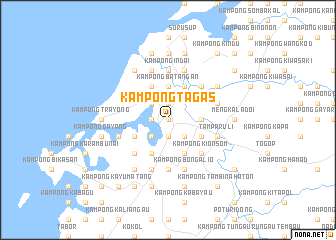
Kampong Tagas (Sabah, Malaysia)Kampong Tagas is a town in the Sabah region of Malaysia. An overview map of the region around Kampong Tagas is displayed below.
regional and 3d topo map of Kampong Tagas, Malaysia ::
Kampong Tagas airports ::
The nearest airport is BKI - Kota Kinabalu Intl, located 29.8 km south west of Kampong Tagas.
Other airports nearby include LBU - Labuan (142.4 km south west), BWN - Brunei Intl (195.3 km south west), LMN - Limbang (199.7 km south west), TWU - Tawau (293.0 km south east), Nearby towns ::
Kampong Panjut (0.0km north) //
Kampong Berungis (0.0km north) //
Kampong Nong Koulod (1.9km south) //
Kampong Marabahai (1.9km north) //
Kampong Raganan (1.8km west) //
Kampong Telibong (2.6km south east) //
Kampong Tambalugu (2.6km south east) //
Kampong Malalin (2.6km south west) //
Kampong Dungun (2.6km north west) //
Mengkabong (2.6km south west) //
Kampong Bantayan (3.7km east) //
Kampong Baharu (3.7km north) //
Kampong Batangan (3.7km north) //
Tuaran (4.1km north east) //
Kampong Dansangai (4.1km south east) //
Kauluan (4.1km south east) //
Kampong Tamparuli (4.1km south east) //
Kampong Tambalang (4.1km north west) //
Kampong Narowot (4.1km south west) //
Kampong Giling (4.1km south west) //
Kampong Piniang (4.1km south west) //
Kampong Rataw (4.1km south west) //
Bundong (5.2km north east) //
Kampong Kionsom (5.2km south east) //
Kampong Salut (5.2km south west) //
Kampong Ratau (5.2km south west) //
Kampong Indai (5.6km north) //
Kampong Tambulaung (5.6km south) //
Kampong Pukak (5.9km north) //
[all distances 'as the bird flies' and approximate]  Places with similar names to Kampong Tagas, Malaysia ::
Disclaimer :: Information on this page comes without warranty of any kind |
||
|
Where is Kampong Tagas? Elevation and coordinates ::
Latitude (lat): 6°9'0"N Longitude (lon): 116°13'0"E
Elevation (approx.): 18m (map arrows pan, magnifying glasses zoom) |
||
|
Visiting Kampong Tagas? Hotel/Accommodation ::
Book a hotel in Kampong Tagas Travel Guide ::
Buy a travel guide for Malaysia rental cars ::
car rental offers GPS waypoint ::
download a GPX waypoint (PoI) of Kampong Tagas for your GPS receiver
|
||