|
search place name
|
||
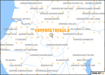
Kampong Tok Gula (Kedah, Malaysia)Kampong Tok Gula is a town in the Kedah region of Malaysia. An overview map of the region around Kampong Tok Gula is displayed below.
regional and 3d topo map of Kampong Tok Gula, Malaysia ::
Kampong Tok Gula airports ::
The nearest airport is PEN - Penang Intl, located 36.3 km north west of Kampong Tok Gula.
Other airports nearby include IPH - Ipoh Sultan Azlan Shah (85.4 km south east), AOR - Alor Setar Sultan Abdul Halim (119.8 km north), LGK - Pulau Langkawi Intl (162.1 km north west), PAN - Pattani (196.3 km north), Nearby towns ::
Kampong Sungai Kechil Ulu (0.0km north) //
Parit Nibong (1.8km west) //
Kampong Tebok Kelantan (1.8km east) //
Kampong Matang (1.8km east) //
Kampong Sungai Tepus (1.8km west) //
Kampong Pasir Hantu (1.8km west) //
Kampong Paya Takong (2.6km north east) //
Kampong Asam Kumbang (3.7km west) //
Kampong Tengah (3.7km west) //
Kampong Jawi Sempit (3.7km east) //
Kampong Raja (3.7km south) //
Kampong Bagan Samak (4.1km north west) //
Kampong Permatang Pasir (4.1km north west) //
Kampong Tepuso (4.1km north west) //
Kampong Matang Simpur (4.1km north east) //
Kampong Bagan Samak (4.1km south east) //
Kampong Telok Sira (5.2km north east) //
Parit Buntar (5.5km west) //
Kampong Besar (5.6km north) //
Sungai Kechil Ilin (5.6km north) //
Kampong Belakang Pekan (5.6km north) //
Kampong Sungai Buaya (5.6km north) //
Kampong Bukit Aping (5.8km east) //
Bandar Baharu (5.8km west) //
Sungai Kechil (5.9km north) //
Lubok Buntar (6.7km north east) //
Kampong Nanas (6.7km north west) //
Kampong Telok (6.7km north west) //
Kampong Chelong (6.7km north east) //
[all distances 'as the bird flies' and approximate] 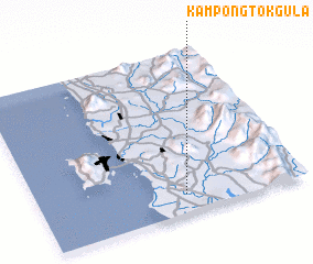 Places with similar names to Kampong Tok Gula, Malaysia :: Disclaimer :: Information on this page comes without warranty of any kind |
||
|
Where is Kampong Tok Gula? Elevation and coordinates ::
Latitude (lat): 5°7'0"N Longitude (lon): 100°33'0"E
Elevation (approx.): 25m (map arrows pan, magnifying glasses zoom) |
||
|
Visiting Kampong Tok Gula? Hotel/Accommodation ::
Book a hotel in Kampong Tok Gula Travel Guide ::
Buy a travel guide for Malaysia rental cars ::
car rental offers GPS waypoint ::
download a GPX waypoint (PoI) of Kampong Tok Gula for your GPS receiver
|
||