|
search place name
|
||
Sungai To' Tuntong (Pulau Pinang, Malaysia)Sungai To' Tuntong is a town in the Pulau Pinang region of Malaysia. An overview map of the region around Sungai To' Tuntong is displayed below.
regional and 3d topo map of Sungai To' Tuntong, Malaysia ::

Sungai To' Tuntong airports ::
The nearest airport is PEN - Penang Intl, located 24.0 km north west of Sungai To' Tuntong.
Other airports nearby include IPH - Ipoh Sultan Azlan Shah (97.2 km south east), AOR - Alor Setar Sultan Abdul Halim (113.3 km north), LGK - Pulau Langkawi Intl (151.4 km north west), PAN - Pattani (195.2 km north east), Nearby towns ::
Kampong Sungai Udang Besar (0.0km north) //
Sungai Setar Besar (1.9km south) //
Kampong Sungai Udang Kechil (1.8km west) //
Telok Ipil (2.6km south east) //
Tanjong Berembang (2.6km south east) //
Rantau Panjang (2.6km south east) //
Parit Tok Mandin (2.6km south east) //
Kampong Tengah (2.6km south west) //
Nibung Tebal (3.7km east) //
Permatang Bogak (4.1km north east) //
Kampong Changkat (4.1km north east) //
Kampung Sungai Aceh (4.1km south west) //
Kampong Sungai Setar (4.1km south east) //
Permatang Keling (4.1km south east) //
Kampong Surau (4.1km south west) //
Kampong Permatang To' Mahat (5.2km south east) //
Kampong Sungai Tongkang (5.2km south west) //
Sungai Bakau (5.2km south west) //
Kampong Tebok Jawa (5.2km south west) //
Kampong Telok (5.8km east) //
Kampong Kedah (5.9km south) //
Kampong Bagan Buaya (6.7km north east) //
Jawi (6.7km north east) //
Kampong Jawi (6.7km north east) //
Simpang Tiga (6.7km south east) //
Bagan Tiang (6.7km south west) //
Kampong Sungai Kota (6.7km south west) //
Bandar Baharu (6.7km south east) //
Kampong Nanas (7.4km east) //
[all distances 'as the bird flies' and approximate] 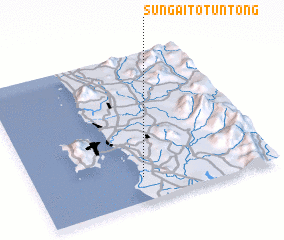 Places with similar names to Sungai To' Tuntong, Malaysia :: Disclaimer :: Information on this page comes without warranty of any kind |
||
|
Where is Sungai To' Tuntong? Elevation and coordinates ::
Latitude (lat): 5°10'0"N Longitude (lon): 100°27'0"E
Elevation (approx.): 6m (map arrows pan, magnifying glasses zoom) |
||
|
Visiting Sungai To' Tuntong? Hotel/Accommodation ::
Book a hotel in Sungai To' Tuntong Travel Guide ::
Buy a travel guide for Malaysia rental cars ::
car rental offers GPS waypoint ::
download a GPX waypoint (PoI) of Sungai To' Tuntong for your GPS receiver
|
||