|
search place name
|
||
Cerro Santos (Chiriquí, Panama)Cerro Santos is a town in the Chiriquí region of Panama. An overview map of the region around Cerro Santos is displayed below.
regional and 3d topo map of Cerro Santos, Panama ::

Cerro Santos airports ::
The nearest airport is DAV - David Enrique Malek Intl, located 79.2 km west of Cerro Santos.
Other airports nearby include BOC - Bocas Del Toro Intl (116.3 km north west), OTR - Coto 47 (139.1 km west), CHX - Changuinola Cap Manuel Nino Intl (143.5 km north west), GLF - Golfito (163.0 km west), Nearby towns ::
Hormiga (1.9km south) //
Quebrada Cangrejo (2.6km south west) //
Las Lagunas (3.7km west) //
Cerro Gavilán (3.7km south) //
Cerro Flores (4.1km north west) //
Los Cebleces (4.1km north west) //
Los Zurdos (5.2km south east) //
Cerro Melón (5.2km south east) //
Guaca (5.5km west) //
Tebujo (5.6km south) //
Llano Tugri (5.6km north) //
Boca Monte (5.8km west) //
Maraca (5.9km south) //
Cerro Miel (5.8km east) //
Cerro Coco (5.8km east) //
Hato Chamí (5.8km west) //
Quebr see Porto Rico Portorrical (5.9km south) //
Alto Cedro (5.9km south) //
Porto Rico (5.9km south) //
Peña Blanca (5.8km east) //
Cerro Palma (6.6km south east) //
Ojo de Agua (6.6km south east) //
Llano Guarumo (6.7km south east) //
Aguacate (6.6km north east) //
Alto Caña (7.3km west) //
Quebrada Canoa (7.3km west) //
Peña Prieta (7.6km south) //
Algarrobo (7.6km west) //
Calabacito de Miranda (7.6km east) //
[all distances 'as the bird flies' and approximate] 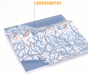 Places with similar names to Cerro Santos, Panama :: Disclaimer :: Information on this page comes without warranty of any kind |
||
|
Where is Cerro Santos? Elevation and coordinates ::
Latitude (lat): 8°26'0"N Longitude (lon): 81°43'0"W
Elevation (approx.): 593m (map arrows pan, magnifying glasses zoom) |
||
|
Visiting Cerro Santos? Hotel/Accommodation ::
Book a hotel in Cerro Santos Travel Guide ::
Buy a travel guide for Panama rental cars ::
car rental offers GPS waypoint ::
download a GPX waypoint (PoI) of Cerro Santos for your GPS receiver
|
||