|
search place name
|
||
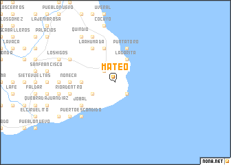
Mateo (Los Santos, Panama)Mateo is a town in the Los Santos region of Panama. An overview map of the region around Mateo is displayed below.
regional and 3d topo map of Mateo, Panama ::
Mateo airports ::
The nearest airport is HOW - Howard, located 164.8 km north of Mateo.
Other airports nearby include PAC - Panama Marcos A Gelabert Intl (172.4 km north), PTY - Panama City Tocumen Intl (189.0 km north), Nearby towns ::
Limón (2.6km north west) //
Punta Mala (2.6km south east) //
Los Destiladeros (4.1km south west) //
La Arena (4.1km south west) //
La Garita (4.1km north east) //
Quebrada La Palma (5.5km west) //
Pedasí (5.9km north) //
Punta Toro (5.9km north) //
La Ahumada (6.7km north west) //
Jobal (6.6km south west) //
Noneca (7.4km west) //
Río Adentro (7.6km west) //
Puerto Escondido (7.8km south west) //
Las Cabezas (8.2km north west) //
Franco (8.3km north west) //
Los Panamaes (9.2km south west) //
La Miel (9.2km south west) //
Quindío (9.2km north west) //
[all distances 'as the bird flies' and approximate] 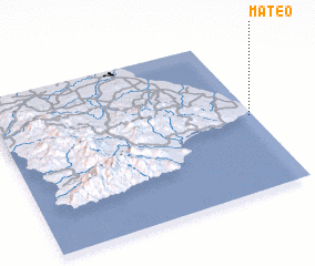 Places with similar names to Mateo, Panama ::
Disclaimer :: Information on this page comes without warranty of any kind |
||
|
Where is Mateo? Elevation and coordinates ::
Latitude (lat): 7°29'0"N Longitude (lon): 80°1'0"W
Elevation (approx.): 15m (map arrows pan, magnifying glasses zoom) |
||
|
Visiting Mateo? Hotel/Accommodation ::
Book a hotel in Mateo Travel Guide ::
Buy a travel guide for Panama rental cars ::
car rental offers GPS waypoint ::
download a GPX waypoint (PoI) of Mateo for your GPS receiver
|
||