|
search place name
|
||
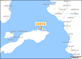
Uvero (Veraguas, Panama)Uvero is a town in the Veraguas region of Panama. An overview map of the region around Uvero is displayed below.
regional and 3d topo map of Uvero, Panama ::
Uvero airports ::
The nearest airport is DAV - David Enrique Malek Intl, located 174.9 km north west of Uvero.
Other airports nearby include HOW - Howard (219.6 km north east), PAC - Panama Marcos A Gelabert Intl (227.6 km north east), BOC - Bocas Del Toro Intl (234.1 km north west), OTR - Coto 47 (237.5 km north west), Nearby towns ::
Platanal (0.8km east) //
Pueblo Nuevo (1.0km north east) //
La Pifá (1.3km west) //
El Divorcio (1.9km east) //
Los Almácigos (3.5km west) //
Las Narices (8.4km west) //
Los Chacareños (10.2km north east) //
Río Negro (10.2km north east) //
Llano de Mariato (11.4km north east) //
[all distances 'as the bird flies' and approximate] 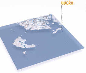 Places with similar names to Uvero, Panama ::
Disclaimer :: Information on this page comes without warranty of any kind |
||
|
Where is Uvero? Elevation and coordinates ::
Latitude (lat): 7°34'42"N Longitude (lon): 81°4'27"W
Elevation (approx.): 16m (map arrows pan, magnifying glasses zoom) |
||
|
Visiting Uvero? Hotel/Accommodation ::
Book a hotel in Uvero Travel Guide ::
Buy a travel guide for Panama rental cars ::
car rental offers GPS waypoint ::
download a GPX waypoint (PoI) of Uvero for your GPS receiver
|
||