|
search place name
|
||
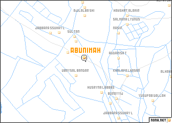
Abū Nı‘mah (Wāsiţ, Iraq)Abū Nı‘mah is a town in the Wāsiţ region of Iraq. An overview map of the region around Abū Nı‘mah is displayed below.
regional and 3d topo map of Abū Nı‘mah, Iraq ::
Abū Nı‘mah airports ::
The nearest airport is KSH - Bakhtaran Shahid Ashrafi Esfahani, located 260.3 km north east of Abū Nı‘mah.
Nearby towns ::
Murād (0.7km north) //
‘Ubays al Bandar (3.5km south west) //
Abū Najm (3.9km north west) //
Al Amīr (4.8km north west) //
Sulţān (5.8km north) //
Ad Darīsāt (6.0km east) //
Ḩusayn al ‘Abbās (7.3km south east) //
Al Ḩājj Şaḩn (8.1km north west) //
Nāşir (8.7km north east) //
Jabbār as Suhayl (9.0km north west) //
Burayyij (9.9km south east) //
[all distances 'as the bird flies' and approximate] 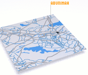 Places with similar names to Abū Nı‘mah, Iraq ::
// Ābnamā (IR)
// Abonnema (NG)
// Abonnema (NG)
// Abennam (GQ)
// Abonamo (PG)
// Abū Na‘āmah (SD)
// Abū an Na‘am (SA)
Disclaimer :: Information on this page comes without warranty of any kind |
||
|
Where is Abū Nı‘mah? Elevation and coordinates ::
Latitude (lat): 32°22'38"N Longitude (lon): 45°38'10"E
Elevation (approx.): 17m (map arrows pan, magnifying glasses zoom) |
||
|
Visiting Abū Nı‘mah? Hotel/Accommodation ::
Book a hotel in Abū Nı‘mah Travel Guide ::
Buy a travel guide for Iraq rental cars ::
car rental offers GPS waypoint ::
download a GPX waypoint (PoI) of Abū Nı‘mah for your GPS receiver
|
||