|
search place name
|
||
Āl al Munbaţiḩ (An Najaf, Iraq)Āl al Munbaţiḩ is a town in the An Najaf region of Iraq. An overview map of the region around Āl al Munbaţiḩ is displayed below.
regional and 3d topo map of Āl al Munbaţiḩ, Iraq ::
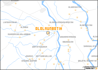
Nearby towns ::
Al Ḩīrah (0.0km north) //
Al Ja‘ārah (1.9km north east) //
Āl Zikrī (2.4km south west) //
Abū Şukhayr (3.2km north east) //
Al Ḩājj Jāsim (3.7km north) //
‘Abd al Wāḩid Shaţnān (4.2km south west) //
Qaryat ‘Aqrab (4.2km south west) //
Āl al Jabūr (4.7km west) //
Al Maḩājīr ash Sharqīyah (5.6km north east) //
Qaryat ad Dasim (6.5km south west) //
Sayyid Muḩammad (7.2km south) //
Dadham ar Rāshid (6.6km east) //
Abū Saddah (7.3km south east) //
Şudūr ash Shallāl (8.2km south east) //
Sayyid ‘Adhari (8.4km south east) //
Qaryat ash Shallāl (8.9km south east) //
Al Ghādūrī (10.4km north east) //
[all distances 'as the bird flies' and approximate] 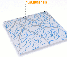 Places with similar names to Āl al Munbaţiḩ, Iraq :: Disclaimer :: Information on this page comes without warranty of any kind |
||
|
Where is Āl al Munbaţiḩ? Elevation and coordinates ::
Latitude (lat): 31°53'0"N Longitude (lon): 44°28'0"E
Elevation (approx.): 21m (map arrows pan, magnifying glasses zoom) |
||
|
Visiting Āl al Munbaţiḩ? Hotel/Accommodation ::
Book a hotel in Āl al Munbaţiḩ Travel Guide ::
Buy a travel guide for Iraq rental cars ::
car rental offers GPS waypoint ::
download a GPX waypoint (PoI) of Āl al Munbaţiḩ for your GPS receiver
|
||