|
search place name
|
||
‘Alī Mūsá (At Taʼmīm, Iraq)‘Alī Mūsá is a town in the At Taʼmīm region of Iraq. An overview map of the region around ‘Alī Mūsá is displayed below.
regional and 3d topo map of ‘Alī Mūsá, Iraq ::
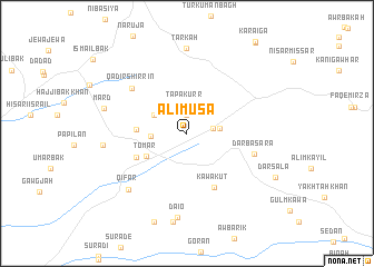
Nearby towns ::
Tapakurr (1.9km north) //
Kurr Suflá (2.2km north) //
Māma Rasn (2.2km east) //
Tapakurr (2.8km north) //
Māmrāsh (2.7km east) //
Qambar (2.9km west) //
Turka (3.2km north west) //
Tomar (4.0km south west) //
Ibrāhīm Zānā (4.2km west) //
Gurgān (4.8km south west) //
Kawakut (5.8km south) //
Dār Ba Sara (5.9km east) //
Qādir Shirrīn (6.4km north west) //
Qifār (7.4km south west) //
Daiō (8.4km south) //
Julḩān (7.0km west) //
Tarkah (8.6km north) //
Mard (7.2km west) //
Mard (7.2km west) //
[all distances 'as the bird flies' and approximate] 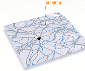 Places with similar names to ‘Alī Mūsá, Iraq ::
Disclaimer :: Information on this page comes without warranty of any kind |
||
|
Where is ‘Alī Mūsá? Elevation and coordinates ::
Latitude (lat): 35°40'49"N Longitude (lon): 44°35'46"E
Elevation (approx.): 718m (map arrows pan, magnifying glasses zoom) |
||
|
Visiting ‘Alī Mūsá? Hotel/Accommodation ::
Book a hotel in ‘Alī Mūsá Travel Guide ::
Buy a travel guide for Iraq rental cars ::
car rental offers GPS waypoint ::
download a GPX waypoint (PoI) of ‘Alī Mūsá for your GPS receiver
|
||