|
search place name
|
||
Bān Laylān (At Taʼmīm, Iraq)Bān Laylān is a town in the At Taʼmīm region of Iraq. An overview map of the region around Bān Laylān is displayed below.
regional and 3d topo map of Bān Laylān, Iraq ::
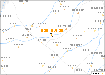
Nearby towns ::
Furqān (3.0km south east) //
Yāhyāwah (3.7km south west) //
Laylān (4.1km south west) //
Khiḑr Bak Qadīm (5.0km north east) //
Qāzān Būlāgh (5.6km north west) //
Tappahlū (7.1km south) //
Nazrāwa (6.6km south east) //
Khiḑr Būlāq (7.5km south east) //
Ḩasan Āwah (7.2km north west) //
Pālkhānah (7.0km east) //
Māmlī (8.6km north) //
Tarjīl (7.5km west) //
Sīāh Manşūr (7.7km south east) //
[all distances 'as the bird flies' and approximate] 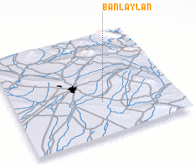 Places with similar names to Bān Laylān, Iraq ::
// Ban Lalun (TH)
// Ban La Lan (LA)
Disclaimer :: Information on this page comes without warranty of any kind |
||
|
Where is Bān Laylān? Elevation and coordinates ::
Latitude (lat): 35°20'23"N Longitude (lon): 44°32'55"E
Elevation (approx.): 408m (map arrows pan, magnifying glasses zoom) |
||
|
Visiting Bān Laylān? Hotel/Accommodation ::
Book a hotel in Bān Laylān Travel Guide ::
Buy a travel guide for Iraq rental cars ::
car rental offers GPS waypoint ::
download a GPX waypoint (PoI) of Bān Laylān for your GPS receiver
|
||