|
search place name
|
||
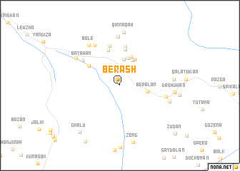
Berash (As Sulaymānīyah, Iraq)Berash is a town in the As Sulaymānīyah region of Iraq. An overview map of the region around Berash is displayed below.
regional and 3d topo map of Berash, Iraq ::
Berash airports ::
The nearest airport is TBZ - Tabriz Intl, located 223.4 km north east of Berash.
Nearby towns ::
Pirdē (2.7km north) //
Pirdmamka (4.1km north) //
Be Palan (3.6km east) //
Sūradē (4.3km north) //
Sargēnīl (4.4km north) //
Āshqōlka (4.5km north east) //
Sinamōka (4.8km north) //
Sārōsh (5.7km north) //
Kūhatān (5.0km north west) //
Kawīnga (5.7km north) //
Kāskān (6.1km north) //
Biyānah (6.3km north) //
Bāyawān (6.1km north west) //
Shekhān (6.1km east) //
Asterokan (7.1km north west) //
Pishtāshān (7.7km north) //
Bolē (7.4km north west) //
Duwaylah (7.0km north west) //
Sewais (6.7km east) //
Qirnāqāw (8.4km north) //
Abu Bakra (6.9km east) //
Dashuwān (7.0km east) //
Zōng (9.1km south) //
Ghālū (8.9km south west) //
Dūkūm (9.8km south west) //
Zūdān (10.3km south east) //
[all distances 'as the bird flies' and approximate] 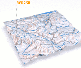 Places with similar names to Berash, Iraq ::
Disclaimer :: Information on this page comes without warranty of any kind |
||
|
Where is Berash? Elevation and coordinates ::
Latitude (lat): 36°22'35"N Longitude (lon): 45°0'29"E
Elevation (approx.): 1110m (map arrows pan, magnifying glasses zoom) |
||
|
Visiting Berash? Hotel/Accommodation ::
Book a hotel in Berash Travel Guide ::
Buy a travel guide for Iraq rental cars ::
car rental offers GPS waypoint ::
download a GPX waypoint (PoI) of Berash for your GPS receiver
|
||