|
search place name
|
||
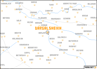
Dargal Sheikh (Dahūk, Iraq)Dargal Sheikh is a town in the Dahūk region of Iraq. An overview map of the region around Dargal Sheikh is displayed below.
regional and 3d topo map of Dargal Sheikh, Iraq ::
Dargal Sheikh airports ::
The nearest airport is VAN - Van, located 166.4 km north of Dargal Sheikh.
Other airports nearby include BAL - Batman (186.1 km north west), Nearby towns ::
Barjīnī (1.9km west) //
Zināwa (2.8km north west) //
Bēskī (3.0km south east) //
Barhawa (3.3km north west) //
Hārūnā (4.4km north west) //
Chīran (4.3km east) //
Tilakura (5.6km north) //
Navāshān (5.5km north east) //
Gul Nazki (4.9km south east) //
Zēwa (5.6km south east) //
Pēzān (6.6km north west) //
Chamtīr (8.1km north) //
Hajista (7.8km south west) //
Birka (8.5km north) //
Bōsaryān (7.9km south west) //
Ōzmāna (7.7km north east) //
Zorawa (8.6km north west) //
Ghāzīāwa (8.6km south east) //
Pēshilk (9.2km north west) //
Dera Nūk (9.8km north west) //
Kosa (10.4km north east) //
Girfīl (10.5km south west) //
[all distances 'as the bird flies' and approximate]  Places with similar names to Dargal Sheikh, Iraq ::
// Tīrkālashk (IR)
Disclaimer :: Information on this page comes without warranty of any kind |
||
|
Where is Dargal Sheikh? Elevation and coordinates ::
Latitude (lat): 37°0'48"N Longitude (lon): 42°52'43"E
Elevation (approx.): 851m (map arrows pan, magnifying glasses zoom) |
||
|
Visiting Dargal Sheikh? Hotel/Accommodation ::
Book a hotel in Dargal Sheikh Travel Guide ::
Buy a travel guide for Iraq rental cars ::
car rental offers GPS waypoint ::
download a GPX waypoint (PoI) of Dargal Sheikh for your GPS receiver
|
||