|
search place name
|
||
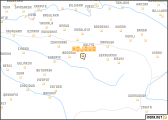
Hojawa (Dahūk, Iraq)Hojawa is a town in the Dahūk region of Iraq. An overview map of the region around Hojawa is displayed below.
regional and 3d topo map of Hojawa, Iraq ::
Hojawa airports ::
The nearest airport is VAN - Van, located 163.9 km north of Hojawa.
Other airports nearby include BAL - Batman (198.9 km north west), Nearby towns ::
Dūliya (2.6km north) //
Banasor (2.7km west) //
Mil Hamān (4.7km north) //
Dera Girnik (4.2km east) //
Rās al ‘Ayn (5.9km north) //
Māngēsh (5.1km north east) //
Zēwik-ē Abū (5.5km north west) //
Shawrik (5.3km west) //
Barōshkī (7.2km north east) //
Bisvki (6.2km east) //
Ārēda (7.6km north west) //
Potapa (8.5km south west) //
Būtērash (7.8km south west) //
Nāvushkē (8.2km north west) //
Kurēmi (9.2km north east) //
Yakmala (10.0km north west) //
Bākhnīf (10.4km south west) //
[all distances 'as the bird flies' and approximate] 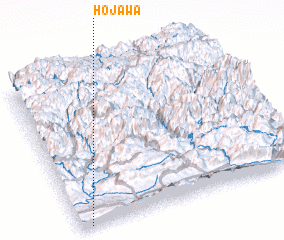 Places with similar names to Hojawa, Iraq ::
Disclaimer :: Information on this page comes without warranty of any kind |
||
|
Where is Hojawa? Elevation and coordinates ::
Latitude (lat): 37°0'32"N Longitude (lon): 43°2'48"E
Elevation (approx.): 828m (map arrows pan, magnifying glasses zoom) |
||
|
Visiting Hojawa? Hotel/Accommodation ::
Book a hotel in Hojawa Travel Guide ::
Buy a travel guide for Iraq rental cars ::
car rental offers GPS waypoint ::
download a GPX waypoint (PoI) of Hojawa for your GPS receiver
|
||