|
search place name
|
||
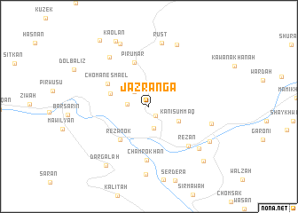
Jazranga (Arbīl, Iraq)Jazranga is a town in the Arbīl region of Iraq. An overview map of the region around Jazranga is displayed below.
regional and 3d topo map of Jazranga, Iraq ::
Jazranga airports ::
The nearest airport is TBZ - Tabriz Intl, located 212.2 km north east of Jazranga.
Other airports nearby include VAN - Van (239.1 km north west), Nearby towns ::
Guizan (1.4km south east) //
Kaolan (2.4km north west) //
Shērkāwa (2.2km west) //
Dār as Salām (2.7km south) //
Kānī Summāq (3.5km south east) //
Chambrok (4.2km north west) //
Rezanok (5.1km south west) //
Sereshma (5.8km north) //
Pīr ‘Umar (5.8km north) //
Chōmān Esmael (5.1km north west) //
Chamrokhān (6.8km south) //
Rēzān (6.4km south east) //
Havrasān (7.4km north west) //
Rust (8.1km north) //
Galālah (6.7km east) //
Rashdūr (7.4km south east) //
Girtik (8.2km north) //
Razhīkāriyān (8.5km south) //
Dīzūk (8.4km north) //
Guman (7.5km south east) //
Dargalah (8.6km south west) //
Kaolān (8.9km north) //
Sāyah (8.8km south east) //
Gaznah (9.7km north west) //
[all distances 'as the bird flies' and approximate] 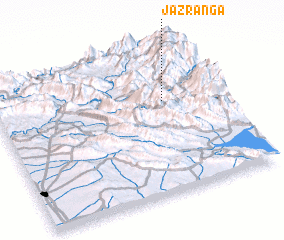
Disclaimer :: Information on this page comes without warranty of any kind |
||
|
Where is Jazranga? Elevation and coordinates ::
Latitude (lat): 36°38'0"N Longitude (lon): 44°45'0"E
Elevation (approx.): 1586m (map arrows pan, magnifying glasses zoom) |
||
|
Visiting Jazranga? Hotel/Accommodation ::
Book a hotel in Jazranga Travel Guide ::
Buy a travel guide for Iraq rental cars ::
car rental offers GPS waypoint ::
download a GPX waypoint (PoI) of Jazranga for your GPS receiver
|
||