|
search place name
|
||
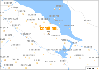
Kānī Bināw (As Sulaymānīyah, Iraq)Kānī Bināw is a town in the As Sulaymānīyah region of Iraq. An overview map of the region around Kānī Bināw is displayed below.
regional and 3d topo map of Kānī Bināw, Iraq ::
Nearby towns ::
Chinarān (1.7km west) //
Tursha (2.7km north west) //
Pēspīyān (2.5km south east) //
Bingirdān (3.1km north) //
Mullā ‘Umar (4.4km north) //
Āliqa-i Pichūk (4.6km north west) //
Āliqa-i Gawra (5.2km north) //
(( Bawātān )) (5.4km north east) //
Turbah (5.5km south east) //
((Kamariyān)) (6.4km north) //
Kānī Aspān (5.7km north west) //
Hanjīra (6.0km north west) //
Gulnayrī (6.9km south) //
Faqē Hājī (6.4km south west) //
Qalāt (7.7km south) //
(( Baymūshah )) (6.6km north east) //
Shūshka (7.1km north west) //
Kānī Shīrān (8.0km south west) //
Khalākān (7.1km west) //
((Shaykh Ismā‘īl)) Flooded by reservoir (8.2km south east) //
Kalakān (8.5km north west) //
Shiwāshan (8.9km north west) //
Topzāwah (10.6km south east) //
[all distances 'as the bird flies' and approximate]  Places with similar names to Kānī Bināw, Iraq ::
Disclaimer :: Information on this page comes without warranty of any kind |
||
|
Where is Kānī Bināw? Elevation and coordinates ::
Latitude (lat): 36°1'38"N Longitude (lon): 44°54'55"E
Elevation (approx.): 683m (map arrows pan, magnifying glasses zoom) |
||
|
Visiting Kānī Bināw? Hotel/Accommodation ::
Book a hotel in Kānī Bināw Travel Guide ::
Buy a travel guide for Iraq rental cars ::
car rental offers GPS waypoint ::
download a GPX waypoint (PoI) of Kānī Bināw for your GPS receiver
|
||