|
search place name
|
||
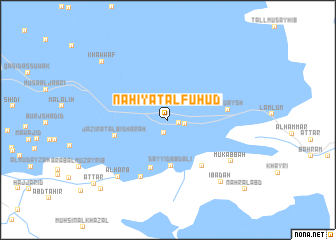
Nāḩiyat al Fuhūd (Dhī Qār, Iraq)Nāḩiyat al Fuhūd is a town in the Dhī Qār region of Iraq. An overview map of the region around Nāḩiyat al Fuhūd is displayed below.
regional and 3d topo map of Nāḩiyat al Fuhūd, Iraq ::
Nāḩiyat al Fuhūd airports ::
The nearest airport is BSR - Basrah Intl, located 101.3 km south east of Nāḩiyat al Fuhūd.
Other airports nearby include ABD - Abadan (158.8 km south east), KWI - Kuwait Intl (227.5 km south east), Nearby towns ::
Al Ḩājj Khālid (1.1km east) //
Al Khāwīyah (1.5km south) //
Āl Jawwil (1.7km east) //
Sayyid Jabr (3.3km north west) //
Sayyid ‘Abd ‘Alī (5.1km south) //
Āl Ismā‘īl (5.6km south) //
Jazīrat al Bishārah (5.4km west) //
Saynakh (6.1km south east) //
Ālbū ‘Aysh (5.9km east) //
Ālbū Shukhayr (6.9km south) //
Mukabbah (7.6km south east) //
Āl Ḩarb (7.9km south west) //
‘Ibādah (8.6km south east) //
Khawwāf (9.0km north west) //
Ālbū Khalīfah (10.0km south west) //
Aţ Ţār (10.0km south west) //
Nahr al ‘Abd (10.7km south east) //
[all distances 'as the bird flies' and approximate]  Places with similar names to Nāḩiyat al Fuhūd, Iraq :: Disclaimer :: Information on this page comes without warranty of any kind |
||
|
Where is Nāḩiyat al Fuhūd? Elevation and coordinates ::
Latitude (lat): 30°58'11"N Longitude (lon): 46°43'22"E
Elevation (approx.): 5m (map arrows pan, magnifying glasses zoom) |
||
|
Visiting Nāḩiyat al Fuhūd? Hotel/Accommodation ::
Book a hotel in Nāḩiyat al Fuhūd Travel Guide ::
Buy a travel guide for Iraq rental cars ::
car rental offers GPS waypoint ::
download a GPX waypoint (PoI) of Nāḩiyat al Fuhūd for your GPS receiver
|
||