|
search place name
|
||
Şāliḩ al Khalaf (Baghdād, Iraq)Şāliḩ al Khalaf is a town in the Baghdād region of Iraq. An overview map of the region around Şāliḩ al Khalaf is displayed below.
regional and 3d topo map of Şāliḩ al Khalaf, Iraq ::
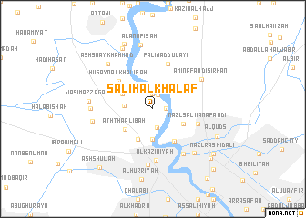
Nearby towns ::
Şāliḩ Ḩasan (1.4km east) //
Ḩājj Sallūm (1.8km north) //
Ḩusayn al ‘Alī (1.9km north) //
Qāsim Mullā ‘Alwān (2.3km south) //
Qaşr Kāz̧im Bāshā (2.9km north west) //
Ḩusayn as Suhayl (3.0km west) //
‘Arab al ‘Azīz (3.7km south) //
As Sayyid Ţāhāʼ (4.0km south west) //
Aḩmad al Ḩasan (3.6km north west) //
‘Abbūd as Sayyid (3.6km north west) //
Al Maşlakh (3.6km south east) //
Ath Tha‘ālibah (3.8km south west) //
Aş Şulaykh (4.6km south east) //
Ḩusayn al Khalīfah (4.9km north west) //
Nazl Salmān Afandī (5.0km east) //
Fālij ad Dulaym (5.8km north) //
Al Kāz̧imīyah (6.3km south) //
Ash Shālikīyah (6.4km south east) //
Az Zahrāʼ (6.9km south) //
Amīn Afandī Sirḩān (6.2km north east) //
Al A‘z̧amīyah (6.9km south east) //
Shaykh ‘Abd al Jabbār (6.3km west) //
Ḩātim as Sulţān (6.4km west) //
Ash Shaykh Aḩmad (7.2km north west) //
Jāsim az Zagam (6.6km west) //
Al ‘Anāfişah (8.0km north) //
‘Abd Allāh al Jāsim (8.0km north west) //
Al Quds (7.4km south east) //
Maḩmūd al ‘Alī (8.5km north) //
[all distances 'as the bird flies' and approximate] 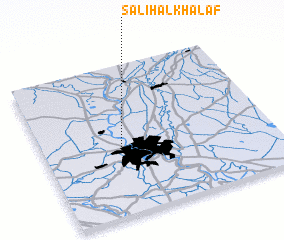 Places with similar names to Şāliḩ al Khalaf, Iraq :: Disclaimer :: Information on this page comes without warranty of any kind |
||
|
Where is Şāliḩ al Khalaf? Elevation and coordinates ::
Latitude (lat): 33°26'0"N Longitude (lon): 44°20'0"E
Elevation (approx.): 38m (map arrows pan, magnifying glasses zoom) |
||
|
Visiting Şāliḩ al Khalaf? Hotel/Accommodation ::
Book a hotel in Şāliḩ al Khalaf Travel Guide ::
Buy a travel guide for Iraq rental cars ::
car rental offers GPS waypoint ::
download a GPX waypoint (PoI) of Şāliḩ al Khalaf for your GPS receiver
|
||