|
search place name
|
||
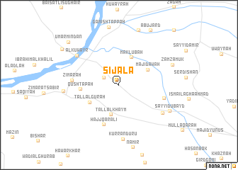
Sijāla (Arbīl, Iraq)Sijāla is a town in the Arbīl region of Iraq. An overview map of the region around Sijāla is displayed below.
regional and 3d topo map of Sijāla, Iraq ::
Nearby towns ::
Dermānao (2.2km north west) //
Maklūbah (4.6km north) //
Tall al Khaym (4.8km south) //
Mājidāwah (4.4km north east) //
Tall al Gūrah (4.6km south west) //
Qūsh Tapah (5.0km west) //
Ḩājj Qaraʼlī (6.6km south) //
Zimārah (6.0km west) //
Ismā‘īl Aghā ‘Abd Allāh (6.2km east) //
Al Kuwayr (7.0km north west) //
Shōrah Zarkah (7.1km south east) //
Kurranduru (8.6km south) //
Şābir (7.1km west) //
Sayyid ‘Ubayd (7.7km south east) //
Zamzamūk (7.6km north east) //
Sherāyah (8.9km north) //
Abū Jard (9.5km north east) //
‘Umar Mindān (9.3km north west) //
Ḩamdān Ţarrāsh (11.1km north east) //
[all distances 'as the bird flies' and approximate] 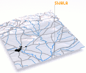 Places with similar names to Sijāla, Iraq ::
Disclaimer :: Information on this page comes without warranty of any kind |
||
|
Where is Sijāla? Elevation and coordinates ::
Latitude (lat): 36°0'23"N Longitude (lon): 43°33'17"E
Elevation (approx.): 277m (map arrows pan, magnifying glasses zoom) |
||
|
Visiting Sijāla? Hotel/Accommodation ::
Book a hotel in Sijāla Travel Guide ::
Buy a travel guide for Iraq rental cars ::
car rental offers GPS waypoint ::
download a GPX waypoint (PoI) of Sijāla for your GPS receiver
|
||