|
search place name
|
||
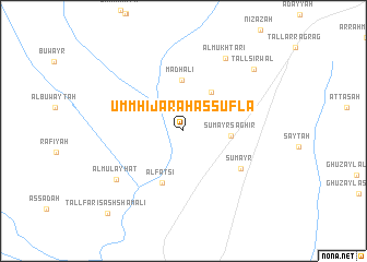
Umm Ḩijārah as Suflá (Nīnawá, Iraq)Umm Ḩijārah as Suflá is a town in the Nīnawá region of Iraq. An overview map of the region around Umm Ḩijārah as Suflá is displayed below.
regional and 3d topo map of Umm Ḩijārah as Suflá, Iraq ::
Umm Ḩijārah as Suflá airports ::
The nearest airport is BAL - Batman, located 243.5 km north west of Umm Ḩijārah as Suflá.
Nearby towns ::
Umm Ḩijārah al ‘Ulyā (4.6km north east) //
Sumayr Şaghīr (4.0km east) //
Maḑhālī (5.2km north) //
Al Faţsī (5.6km south) //
Sumayr (6.1km south east) //
Al Mukhţarī (8.1km north east) //
Al Mulayḩāt (7.5km south west) //
Sirwāl (8.6km north east) //
Tall Sīrwāl (8.6km north east) //
Tall Fāris ash Shamālī (10.5km south west) //
[all distances 'as the bird flies' and approximate]  Places with similar names to Umm Ḩijārah as Suflá, Iraq :: Disclaimer :: Information on this page comes without warranty of any kind |
||
|
Where is Umm Ḩijārah as Suflá? Elevation and coordinates ::
Latitude (lat): 36°6'12"N Longitude (lon): 42°38'7"E
Elevation (approx.): 243m (map arrows pan, magnifying glasses zoom) |
||
|
Visiting Umm Ḩijārah as Suflá? Hotel/Accommodation ::
Book a hotel in Umm Ḩijārah as Suflá Travel Guide ::
Buy a travel guide for Iraq rental cars ::
car rental offers GPS waypoint ::
download a GPX waypoint (PoI) of Umm Ḩijārah as Suflá for your GPS receiver
|
||