|
search place name
|
||
‘Uwaylim (Al Anbār, Iraq)‘Uwaylim is a town in the Al Anbār region of Iraq. An overview map of the region around ‘Uwaylim is displayed below.
regional and 3d topo map of ‘Uwaylim, Iraq ::
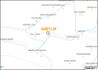
Nearby towns ::
Tall Yūsuf (4.5km west) //
Hudayb al Ḩusayn (6.9km north) //
Al Ḩājj Faraḩ (6.6km north west) //
Zayn ‘Alwān (6.9km north west) //
‘Abd Allāh al ‘Awwād (7.8km south west) //
Ḩasan al Lājī (7.1km north west) //
ShaykhDir‘ al Muḩammad (8.5km south) //
[all distances 'as the bird flies' and approximate]  Places with similar names to ‘Uwaylim, Iraq :: Disclaimer :: Information on this page comes without warranty of any kind |
||
|
Where is ‘Uwaylim? Elevation and coordinates ::
Latitude (lat): 33°25'20"N Longitude (lon): 44°3'8"E
Elevation (approx.): 38m (map arrows pan, magnifying glasses zoom) |
||
|
Visiting ‘Uwaylim? Hotel/Accommodation ::
Book a hotel in ‘Uwaylim Travel Guide ::
Buy a travel guide for Iraq rental cars ::
car rental offers GPS waypoint ::
download a GPX waypoint (PoI) of ‘Uwaylim for your GPS receiver
|
||