|
search place name
|
||
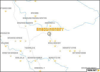
Ambodimanary (Mahajanga, Madagascar)Ambodimanary is a town in the Mahajanga region of Madagascar. An overview map of the region around Ambodimanary is displayed below.
regional and 3d topo map of Ambodimanary, Madagascar ::
Ambodimanary airports ::
The nearest airport is WAI - Antsohihy Ambalabe, located 57.3 km west of Ambodimanary.
Other airports nearby include HVA - Analalava (90.8 km north west), ZWA - Andapa (124.9 km east), WMN - Maroantsetra (134.8 km east), WMR - Mananara Avaratra (186.5 km south east), Nearby towns ::
Ambalamanary (1.9km south) //
Antanambe (2.6km south east) //
Marerano (3.7km north) //
Andilamboay (4.1km south east) //
Ambararata (6.6km south east) //
Ambodibonara Avaratra (7.7km north west) //
Marofototra (9.1km south east) //
Tsiamalao (9.1km south west) //
Ankiabe (9.2km north west) //
[all distances 'as the bird flies' and approximate] 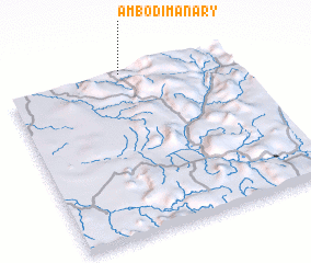 Places with similar names to Ambodimanary, Madagascar ::
// Ambodimanara (MG)
// Ambodimanara (MG)
// Ambodimanara (MG)
// Ambodimanary (MG)
// Ambodimanary (MG)
// Ambodimanary (MG)
// Ambodimanary (MG)
// Ambodimanary (MG)
// Ambodimanary (MG)
// Ambodimanary (MG)
Disclaimer :: Information on this page comes without warranty of any kind |
||
|
Where is Ambodimanary? Elevation and coordinates ::
Latitude (lat): 15°0'0"S Longitude (lon): 48°31'0"E
Elevation (approx.): 248m (map arrows pan, magnifying glasses zoom) |
||
|
Visiting Ambodimanary? Hotel/Accommodation ::
Book a hotel in Ambodimanary Travel Guide ::
Buy a travel guide for Madagascar rental cars ::
car rental offers GPS waypoint ::
download a GPX waypoint (PoI) of Ambodimanary for your GPS receiver
|
||