|
search place name
|
||
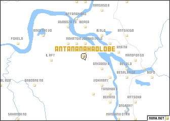
Antananahaolobe (Toliara, Madagascar)Antananahaolobe is a town in the Toliara region of Madagascar. An overview map of the region around Antananahaolobe is displayed below.
regional and 3d topo map of Antananahaolobe, Madagascar ::
Antananahaolobe airports ::
The nearest airport is ZVA - Miandrivazo, located 25.0 km north of Antananahaolobe.
Other airports nearby include MOQ - Morondava (126.1 km south west), WFI - Fianarantsoa (256.0 km south east), Nearby towns ::
Androfia (1.9km north) //
Mahatsinjo-Mahavelo (3.7km north) //
Antiabe (4.1km north west) //
Ankabova (3.9km south east) //
Mahatsara (5.1km north west) //
Isalo (6.6km north east) //
Vohimary (6.6km south east) //
Ambalanomby (6.4km north east) //
Andiambiby (6.4km north east) //
Anosimanitsy (6.4km south east) //
Bepea (7.4km north) //
Ilafy (7.0km west) //
Soatanana (7.2km east) //
Ambalasatrana (7.6km south) //
Adabozato (8.2km north west) //
Tanambao (9.1km south east) //
[all distances 'as the bird flies' and approximate] 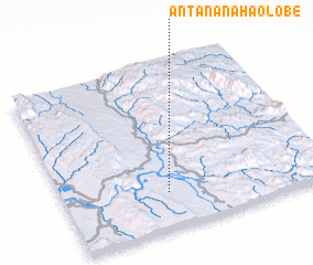 Places with similar names to Antananahaolobe, Madagascar :: Disclaimer :: Information on this page comes without warranty of any kind |
||
|
Where is Antananahaolobe? Elevation and coordinates ::
Latitude (lat): 19°47'0"S Longitude (lon): 45°24'0"E
Elevation (approx.): 68m (map arrows pan, magnifying glasses zoom) |
||
|
Visiting Antananahaolobe? Hotel/Accommodation ::
Book a hotel in Antananahaolobe Travel Guide ::
Buy a travel guide for Madagascar rental cars ::
car rental offers GPS waypoint ::
download a GPX waypoint (PoI) of Antananahaolobe for your GPS receiver
|
||