|
search place name
|
||
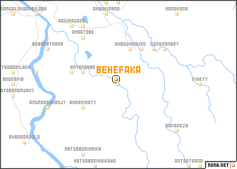
Behefaka (Antsiranana, Madagascar)Behefaka is a town in the Antsiranana region of Madagascar. An overview map of the region around Behefaka is displayed below.
regional and 3d topo map of Behefaka, Madagascar ::
Behefaka airports ::
The nearest airport is AMB - Ambilobe, located 23.0 km north west of Behefaka.
Other airports nearby include VOH - Vohemar Vohimarina (91.0 km east), NOS - Nosy-be Fascene (92.3 km west), DIE - Antsiranana Arrachart (106.0 km north), SVB - Sambava (153.6 km south east), Nearby towns ::
Maropamba (0.0km north) //
Ambodimadiro (5.8km north) //
Antanambe (5.7km west) //
Ampasimaty (6.6km south west) //
Amporaha (6.6km north east) //
Ambodimanga (7.4km west) //
Bobamakotra (7.8km north east) //
Sondranary (9.1km north east) //
Ambatobe (9.2km north west) //
[all distances 'as the bird flies' and approximate] 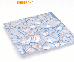
Disclaimer :: Information on this page comes without warranty of any kind |
||
|
Where is Behefaka? Elevation and coordinates ::
Latitude (lat): 13°18'0"S Longitude (lon): 49°10'0"E
Elevation (approx.): 68m (map arrows pan, magnifying glasses zoom) |
||
|
Visiting Behefaka? Hotel/Accommodation ::
Book a hotel in Behefaka Travel Guide ::
Buy a travel guide for Madagascar rental cars ::
car rental offers GPS waypoint ::
download a GPX waypoint (PoI) of Behefaka for your GPS receiver
|
||