|
search place name
|
||
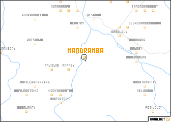
Mandramba (Toliara, Madagascar)Mandramba is a town in the Toliara region of Madagascar. An overview map of the region around Mandramba is displayed below.
regional and 3d topo map of Mandramba, Madagascar ::
Mandramba airports ::
The nearest airport is MXM - Morombe, located 129.1 km north west of Mandramba.
Other airports nearby include TLE - Toliara (136.3 km south west), Nearby towns ::
Ampisoha (2.5km north west) //
Ampasy (3.9km south west) //
Bevatry (7.6km north) //
Anjiojio (7.1km west) //
Ambalavy (8.8km north east) //
Miary Afovoany (9.0km south west) //
Miary Avaratra (9.0km south west) //
Ankazoabo (10.1km north east) //
Bekopay (10.1km south west) //
[all distances 'as the bird flies' and approximate]  Places with similar names to Mandramba, Madagascar ::
// Mindrem (NO)
// Monte Romo (CR)
// Mandrem (IN)
// Mantraim (GH)
// Mindorim (KP)
// Montiéramy (FR)
// Mandurama (AU)
// Montramé (FR)
// Montrem (FR)
// Manteremu (SL)
Disclaimer :: Information on this page comes without warranty of any kind |
||
|
Where is Mandramba? Elevation and coordinates ::
Latitude (lat): 22°21'0"S Longitude (lon): 44°27'0"E
Elevation (approx.): 411m (map arrows pan, magnifying glasses zoom) |
||
|
Visiting Mandramba? Hotel/Accommodation ::
Book a hotel in Mandramba Travel Guide ::
Buy a travel guide for Madagascar rental cars ::
car rental offers GPS waypoint ::
download a GPX waypoint (PoI) of Mandramba for your GPS receiver
|
||