|
search place name
|
||
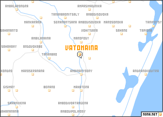
Vatomaina (Toamasina, Madagascar)Vatomaina is a town in the Toamasina region of Madagascar. An overview map of the region around Vatomaina is displayed below.
regional and 3d topo map of Vatomaina, Madagascar ::
Vatomaina airports ::
The nearest airport is TMM - Toamasina, located 58.4 km north east of Vatomaina.
Other airports nearby include TNR - Antananarivo Ivato (174.6 km west), SMS - Sainte Marie (179.1 km north east), Nearby towns ::
Tonandava (1.8km east) //
Ambinanynony (3.7km south) //
Marofody (3.7km north) //
Vohitsara (5.8km north) //
Mahatera (7.4km south) //
Androsalabo (7.0km west) //
Tanambao (7.0km west) //
Mahatera (7.6km south) //
Ambodisovoka (7.6km north) //
Seranantsara (8.2km north west) //
Marosoroka (10.2km north east) //
Berano (10.2km south west) //
[all distances 'as the bird flies' and approximate]  Places with similar names to Vatomaina, Madagascar ::
// Vitaminnyy (RU)
// Footman (US)
// Vaitimėnai (LT)
// Fidīmīn (EG)
// Fatumean (TP)
// Vadamunai (LK)
// Fetʼimeny (ET)
// Fotoména (CM)
Disclaimer :: Information on this page comes without warranty of any kind |
||
|
Where is Vatomaina? Elevation and coordinates ::
Latitude (lat): 18°34'0"S Longitude (lon): 49°7'0"E
Elevation (approx.): 51m (map arrows pan, magnifying glasses zoom) |
||
|
Visiting Vatomaina? Hotel/Accommodation ::
Book a hotel in Vatomaina Travel Guide ::
Buy a travel guide for Madagascar rental cars ::
car rental offers GPS waypoint ::
download a GPX waypoint (PoI) of Vatomaina for your GPS receiver
|
||