|
search place name
|
||
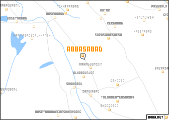
‘Abbāsābād (Iran)‘Abbāsābād is a town in Iran. An overview map of the region around ‘Abbāsābād is displayed below.
regional and 3d topo map of ‘Abbāsābād, Iran ::
‘Abbāsābād airports ::
The nearest airport is KER - Kerman, located 23.7 km south of ‘Abbāsābād.
Nearby towns ::
Kahnūj-e Modīm (2.2km south east) //
‘Alīābād-e Jar (3.8km south) //
Shāhābād (6.4km south) //
Sar Asīab-e Shesh (6.6km north east) //
Zangīābād (8.0km south) //
Deh Gabr (8.5km south east) //
Kerdābād (9.4km north east) //
[all distances 'as the bird flies' and approximate] 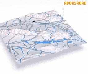 Places with similar names to ‘Abbāsābād, Iran ::
// 'Abāsābād (IR)
// Abbāsābād (IR)
// Abbāsābād (IR)
// Abbāsābād (IR)
// Abū Zabad (SD)
// Abbāsābād (PK)
// ‘Abbāsābād (IR)
// ‘Abas̄ābād (IR)
// ‘Abāsābād (IR)
// ‘Abbasābād (IR)
Disclaimer :: Information on this page comes without warranty of any kind |
||
|
Where is ‘Abbāsābād? Elevation and coordinates ::
Latitude (lat): 30°29'0"N Longitude (lon): 56°54'0"E
Elevation (approx.): 1718m (map arrows pan, magnifying glasses zoom) |
||
|
Visiting ‘Abbāsābād? Hotel/Accommodation ::
Book a hotel in ‘Abbāsābād Travel Guide ::
Buy a travel guide for Iran rental cars ::
car rental offers GPS waypoint ::
download a GPX waypoint (PoI) of ‘Abbāsābād for your GPS receiver
|
||